Monday, December 29, 2008
Clipper on the way, two more storms to track
Models made some dramatic changes to the track of the system since last night. A 100km South shift to the track changed the course of this system by quite a bit. The models also showed a weaker solution.
Despite all that changes, the forecast still did not change much. 5-10 cm of snow is still in play for the GTA and 10cm or more is possible around the Niagara Peninsula.
We are once again in an active pattern. After the Clipper there are quite a few things to look at. With the block up north, abundant cold air is right above us. The gulf keep sending the warm moiture up here and with the dynamics of a -NAO, an active jet will bring storm after storm to the eastern half of North America.
Models had not been doing a good job with these storms and that made me not wanting to look into them unless the storm is 4 days out. Pattern ins the key and we are locked into a good one right now.
I will have the warning set up by tomorrow morning with further details on this clipper.
Sunday, December 28, 2008
Strong Clipper close to a winter storm
Sunday Dec 28th 2009 5:30PM EDT-
A small Clipper will track into central Ontario and is expected to bring 5-10 cm of snow to a few areas. Snowfall warning is issued for these regions
A strong but fast moving Clipper will move in overnight into the last day of 2008. A swath of 5-15cm of snow is associated with this system. Due to the fast moving nature of Clippers, overall accumulations wont be topping major amounts, however, bursts of heavy snow is expected. Snowfall watch had been issued for 2/3 of Southern Ontario. It could be expanded and/or upgraded to Winter Storm watch as the even tracks closer.
Yes, here I introduce you to the newest map featured at my blog. The EC style warning maps will be used to better represent winter conditions for exact regions of Southern Ontario. Another Feature I would like to show you is the event alert bar to the left. When a weather even is in the forecast or is occuring in Southern Ontario, it will be shown on it.
Toronto and the rest of southern Ontario is expected to see a few cm of flurries tomorrow but the bulk of the small accumulations will stay up north. The snow may or may not stick to the ground but that should not be our worry as a much stronger system will move into our region.
Right now, the track had been pretty consistent with this. Areas in the watches should get close to 10 cm of snow from this. As the even tracks closer, things may change, but that is the thinking currently.
The winter storm possibility I've shown you yesterday did not look too good in the previous few models. The bulk of the moisture got tracked Further east. However, this storm still remains a possibility as I am still looking for consistency and the time range for the models.
I hope you enjoy the new features and I will see you tomorrow!
Saturday, December 27, 2008
Mild weather wont last, winter makes an immediate return
Snow is currently melting rapidly as the temperature holds at 10 degrees. We are definitely used to see this from time to time during the winter and it looks like this one wont last too long. We will be back at winter in 2 more days!
As always, a winter rain storm always have a sharp cold front which can drop the temperature down alot in a short period of time. Sunday evening will be the time for that to happen, and two clippers will follow.
The first one looks to pass north of us, bringing us a few cm of flurries or wet flurries.
The second one looks stronger and will go further south and should be here right before New Years eve, I will be watching this one closely and we could receive 5-10 cm from this.
With NAO dropping and a blocking pattern setting up. We are heading for a very snowy early Jan. A rather potent storm is already showing itself on the models and I have pretty high confidence that this storm will take place. Thus I have set up storm possibility already.
The dynamics of this storm looks perfect, we wont be worrying about warm air at all with this pattern and the first low looks to track right into us. If this thing is strong and the energy of the low transfers closer to the coast and slower, we are looking at a major winter storm.
As I am typing this, green grass is already showing itself at the park back of my building, fortunately, it looks like I wont be seeing that for too long!
Tuesday, December 23, 2008
A wet Christmas
rain during Christmas eve anyone? I thought so, thats a mood stinker, especially after all the snow we are getting, but unfortunately, that is what we are looking at this year.
This new system, winter storm jack, is an interesting one, not only is this a slow mover and a big dude, it will also warm up the temperature dramatically, we are currently sitting at -10 and our temperature for tomorrow is forecasted to be +6. However, this system does have quite a bit of snow associated as well.
Before we get into that annoying rain stuff by late tomorrow morning, we are still looking at 10-15 cm of snow. for most of Southern Ontario and higher amount further North My thinking is that the cold air and snow back could lower the surface temp further than expected, we could see the changeover a little later than expected. ( Ernesto was on example)
the pattern for the next week after this storm look gloomy and mild. Temperature could possibly reach the teens some point this weekend and early next week. however, I do expect this to be a short lived pattern, cold air and green land block will return soon after. Our snowpack right now could even survive until then, but it will be the brown kind of stuff.
Hey Santa, if you are reading my forecast right now, I recommend you to bring Ruldolph tommorow night!
Saturday, December 20, 2008
George was quite a storm, Ivan brings same stuff, different presentation
The storm after storm pattern continues as yet another winter storm is on its way, and quite possibly another one pre-Christmas.
Temperatures today will be quite cold, wind chill values almost reached -30 earlier in the morning today and afternoon wont be warming up too much. Followed by another day of strong wind and blizzard like conditions, welcome to the real Canadian winter Toronto!
We could get some lake effect throughout today but I don't see any mmajor accumulations, some places along the Horseshoe could get 5cm.
Environment Canada Just issued the second winter storm watch in 3 days, which I find quite exciting and funny at the same time. Looks like we wont get a break! Did I mention not getting a break? After this storm passed, yet another one will be on the developing stages!
Now lets break down the exact dynamics of Ivan.
We should see snow starting in the evening for Southern Ontario by evening and this thing wont go away until tomorrow Evening. A very strong round of lake effect follows behind. We may not see as heavy of snow rate like the last one, but wind will be once again very strong with this system, perhaps even stronger than the last one. Snow ratio will also be very high with this system, causing more snow than the models show. Up to 25 cm is quite possible in Toronto.
Once this thing moves to Southeastern Ontario and Southern Quebec, it will strengthen rapidly and could bring 30+ cm to places like Montreal and especially eastern townships. Eastern US is in the same bought ares in Main could get alot of snow!
Today looks like the last day you want to do Christmas shopping in and please get ready for yet another round of wintery weather!
Thursday, December 18, 2008
Storm Sensors Tingling, Major Winter Storm coming, George Observations
Friday
10:00 AM EST - my forecast earlier saying two cm, looks like a bust, cause right now there is 4-5 cm fallen in Toronto and the heaviest band is still yet to move in. TWN and its 10cm can be thrown out the window.
9:49 AM EST- really starting to get heavy, looks like we are not gonna get dry slotted either.
8:30 AM EST- snow starting to pick up in intensity just I am about to leave schoolo "perfect" timing
7:40 AM EST- snow starting in Toronto, should pick up in intensity very soon
6:40 AM EST- snow being reported in Hamilton, Toronto still an hour away
6:10 AM EST - first precip band approaching Toronto, 1-2 hour away,
2:00 AM EST - storm is now at the edge of Southern Ontario
Thursday
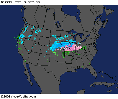
10:00 PM EST- storm continues to develop, very fun to watch
9:20 PM EST - NAM trended further south than the 18z, which is pretty much expected and no surprise, all the forecasts is still right on track. GFS is the last model I'm gonna use for this storm.
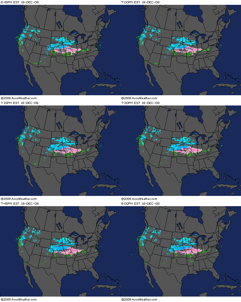
8:00 PM EST - storm is exploding right off Colorado into the US midwest, it is really fun to see this beast develops. I will post a large radar image every 2 hours for the next 4 frames(10:00pm, 12:00pm, 2:00am and 4:00am) which the first shield of precip should move into Southern Ontario. I might post some updates on the models or others in between.
Further Details on Winter Storm George
Looks like my forecast issued yesterday should be bang on. Models indeed trended north and now it is slowly getting back to what it said 2 days ago. I would now confidently say that the amount should be more likely the higher end of total forecasted.
The latest NAM and GFS both trended further north, having an average of 20-30 cm of snow for Toronto. The storm will move across in a hurry but this will probably bring the heaviest bands of snow ever seen in TO in a long time. The temperature will be very cold and the wind will be very strong, blizzard conditions could be expected for a few hours in many places. Here is an exact timeline of events for Toronto, the time should be 1 hour earlier every 75 km west you go.:
6-8 - Flurries at times heavy from Toronto to Oakvile. Snow moves in to Hamilton.
8-10 - light snow turning into heavy snow in Toronto. amount at 10 AM - 2 cm
10 -Noon - moderate to heavy snow steadily falling, amount at Noon - 7 cm
Noon-3 PM - I think this is when the heavest snow will fall, blizzard conditions will be expected, amount at 3 PM - 15 cm
3 PM - 6 PM - Heavy snow slowly tapers off to moderate-light snow, amount at 6 PM - 20 cm
6PM - 10 PM - snow tapers off, final accumulation 22cm
The ingredients for this storm is the closest I've seen from a blizzard and condtions will be more than terrible outside. I advise those of you who are driving to work or school to not go because you might have a very tough drive and it will be dangerous. Even walking to school could be tricky(especially the way back).
The next thing I am going to look at is Ivan, this one will definitely not be as severe but could bring quite a dumping as well. While winter storm warning is issued for George, Ivan might get some snowfall warnings especially in eastern Ontario. I think everybody in Southern Ontario will get equal share once both storm passes.
I will be constantly updating on the track, observations and radar of this upcoming storm. This is the first time this winter I am going into Major winter storm mode.
Wednesday, December 17, 2008
George will be a Southwestern Special
Monday Dec 15 2008 6:00 pm EST-
A potentially biggest winter storm of the season will move just south of Southern Ontario. A Colorado low
associated with alot of moiture is set to move into Southern Ontario by Thursday. The low will
move directly east after reaching illinois across into South of the Great Lakes.The last few days saw the storm move further South, dimishing
the ice storm threat and even lessered the amount. Ares in Southeastern Ontario may score a miss as the low passes below them. Freezing rain is stil
possible alone the shores of lake Erie but this will remain a snow event. Snow begans Overnight Thursday and will proceed into the evening hours,
strong wind is likely to be associated and driving conditions will be terrible for both rush hours Friday. A general 20-30 cm is expected South of
the London to Hamilton line and the amount will lessen the further north you go. Lake enhancement could increase the amount of snow at the west end of lake Ontario
Forecast for selected cities:
Toronto 15-25 cm
Hamilton 20-30 cm
London 20-25 cm
Windsor - 20-25 cm ice pelletes mixing in
Barrie - 10-15 cm
Niagara Region - 20-30 cm Freezing rain likely
Kingston - 10-20 cm
Ottawa - 3-5 cm
Sudbury - 0 cm
The models just kept moving South throughout today and at one point, NAM is even putting Toronto out of it. With the oz run out, I think I have the idea for this storm.
Originally, the models were mishandling the arctic air sitting in Manitoba and Northern Ontario. Now that the models got better grip, they trended it further South. I still think they are overexaggerating the south track a little bit the last two runs. The 00z NAM turned back to its 12z solution and I expected a slight sway North as the final track. This will put the heaviest snow around St.Thomas and Niagara region.
Hamilton into Pickering could get some lake enhancement with ESE wind. Which could bump up the amount a bit. I think the total will not exceed 30 cm. Things may not look as good as 2 days ago, but this will still be quite a storm.
Winter Storm watches issued for Southwestern Ontario. This could turn into warning by tommorow morning. Unless the models continue a south track, which I don't think is likely, this is what I think we will be getting.
Attention will be turned to the next winter storm and the one after that around Christmas(yes, another one is coming) by tommorow night, but the next two runs are still key to the track of this storm. Observations will start tommorow night.
Final Forecast on hold
The afternoon runs of the models had been terrible, trending much further south than originally. NAM even had the storm entirely missing Toronto. All the other models also show this trend. Thus for the reason for me to halt the forecast at least until the 0z model comes out and have the final forecast out by midnight.
Tuesday, December 16, 2008
Heavy snow falling, 5 x more to come
The heaviest snowfall I've seen so far this winter is falling right before my eyes right now as Winter Storm Helen rolls in, totals are already approaching 5 cm and we are only at 1/3 of this storm. Due to the higher snow/liquid ratio, we could quite possibly pick up 15 cm when this is done, and to think this is only the beginning.
Winter Storm George will move into Southern Ontario quickly around midnight Friday and will continue to snow all day Friday. I think there is actually a high chance of school closing on this last day of school before the holidays.
My final forecast which will be release sometime tomorrow will see the track about 100-150 further South, Area around Hamilton and Niagara could be the sweet spot of this storm and I can see them picking up the highest amounts(30-40 cm). Models has been fairly good with this system and should be a easy one to predict. Like mentioned previously, this storm will quite possibly stay in peoples memories for years.
Looks like ice threat is diminished, folks alone Erie and around the Niagara Pennisola will probably see some freezing rain but the threat will not be too big. This storm should stay mainly snow.
Taking a look at Ivan tells me this one will be a tough one to track and forecast. The models have this system "stalling" around the great lakes, with strong winds and cold temperatures, we could be looking at a blizzard. However, the confidence in models for this storm is not very high and things could change, I think this will be a big snow storm, but the exact nature of it is still yet to be determined.
Looking at the long range tells me Ivan will not be the last of the storm train. GFS brings a storm after storm tracking up the east. We may as well surpass the winter average snowfall at the end of this month!
Ivan Will be Potent as well, Helen Begins the 1-2-3 punch tonight
-11:00 PM EDT Snow is absolutely intense right now, I would say we got 2-3 cm on the ground thus far, going outside right now to check it out. I will have a new post up at midnight.
-10:00 PM EDT Moderate Snow falling and the grass is already starting to get covered.
- 8:40 PM EDT Hamilton starts to snow and most of Southwestern Ontario is getting steady moderate snowfall. Snow should start in the GTA in another hour.
Looks like Ivan wont be too shabby either, and even has the slight possibility to exceed George. The consitency of the models on all these three storms had so far been amazing( well, except one, which I will discuss after) and now most models brings another potent winter storm our way in the form of even colder snow.
Ivan will take the form of a phased solution of an Alberta Clipper and a strong gulf low pressure off Texas, the stalling action once it phases in the Apps could spell significant snow to many regions. We are as close to certain to a white Christmas as we can get to. I will not put any details on the exact accumulations until at least Thursday, partly due to the fact we are far away, but mainly because we are gonna be dealing with the next few days.
Helen is already bringing light snow right now to the extreme southern Ontario. We will be getting our snow starting in 2 1/2 hours. Snow could be quite heavy overnight and you should wake up to see quite a bit of snow on the ground. I am still holding on from this early morning's prediction. Observations of Helen will be done on this thread(updated on the top) until 11 pm, which I will have a new thread up on the latest information.
George is a phenomena of its own. The models is fairly consistent with the track if not slightly southward. The last NAM did a 180 degree flop and pushed it 150 km South, which now definitely is an outlier( in fact, the lastest GFS is even slightly further North). I am still holding on to my earlier forecast but I could see the heaviest band further south on the final forecast.
I will be quite busy today, switching from looking at the radar, the model, outside and the forum. Thats what happens when a number of snow storm is here. Before I end this post, I would want to add that my gut says that mother nature may be saving the best for the last.
Tuesday night snow named , a strong 1-2-3 punch is close to certain
Tuesday Dec 16 2008 5:00 AM EST - A moderate low pressure system off colorado moves quickly into Southern Ontario late Tuesday, bringing 5-15 cm of snow to most regions. Recent observations and models show a stronger precip band from this system, but due to the fast moving nature of this storm, there wont be a significant amount of snow. Despite that, snow associated with this system could be at times heavy and could accumulate quite a bit. Up to 10 cm of snow is expected in the Southwestern Ontario and up to 15 cm of snow is expect in the southeast. Mixing will be fairly minimal if any in the Niagara Peninsula and the snow/liquid ratio should be quite high with this storm. Forecast for selected cities:
Toronto 10 cm
London 5-10 cm
Windsor - 5-10 cm
Barrie - 5-10 cm
Niagara Region - 10 cm 20% chance of Freezing rain
Kingston - 10-15 cm
Ottawa - 5-10 cm
Subary - 5 cm
Well what do you know, looks like this little Helen might actually bring the biggest accumulations in the GTA thus far( well this will probably be the case for one more day). Since 10 cm or more is expected for a city, this winter storm is now named. The models trended this thing a little stronger and because of the consistency shown and the high snow/liquid ratio expected, we are gonna get more snow than originally expected. Well, I would have been crazy over how this storm is turning out, but that will not be the case, since what might be coming up next is crazier.
Winter Storm George had already been a beast yesterday, the confidence level on this just raised even higher with the new models. The last two runs only verifies the legitimacy of this system and the track had not changed much. We are still under heavy heavy snow according to ALL the models and its just amazing how much they are agreeing with each other right now. I don't think I have much more to say about this other than the fact that I hope this will not change.
The threat of a rainstorm is diminishing and even the threat of a ice storm is put on hold for now. How does an all out blizzard sound? Too good to be true? we will be talking about that the next few days.
And what do you know, yet another winter threat could be on the scene the last day of this week, right now, I don't have much to say about this one other than the fact that the chance of this winter storm occuring is getting likier with every model run. We are still too far away to talk about the amounts, but let me tell you, this could be a very good way to end what could be an historical week in the making.
Monday, December 15, 2008
Powerful Winterstorm George a double threat, a week of crazy winter weather
A warning before reading this post, this will be the longest blog post I will probably write this winter and I have a great reason for it. Here it is:
Monday Dec 15 2008 6:00 pm EST- A potentially biggest winter storm of the season will move into Southern Ontario. A Colorado low associated with alot of moiture is set to move into Southern Ontario by Thursday. The low will move directly east after reaching illinois across into the Great Lakes region Due to similar difference between Upper air temp and surface temp or perhaps a even warmer upper level could cause a major ice storm. Areas Further Northeast of the low will see all or mainly snow and areas Southwest will have snow changing to freezing rain and ice pellets. Lots of moisture is associated and whatever precipitation that will fall will be big. Snow accumulation of 20 cm is possible in 12 hours and up to 40 cm of snow could fall and significant ice could accumulate. Details still isn't completely clear yet but as things stands right now, this will be a very big winterstorm. Forecast for selected cities: Toronto 20-30 cm Freezing rain possible London 15-25 cm Freezing rain likely Windsor - 10-20 cm snow changing to Freezing rain and ice pellets to rain Barrie - 20-30 cm Niagara Region - 15-25 cm Freezing rain likely Kingston - 25-35 cm Ottawa - 20-25 cm Sudbury - 5-10 cm
It doesn't take much to get me excited and this storm might as well be an overkill. What was originally a interesting winter storm looks to turn out even more than that. Winter Storm George will surely form and things could be very interesting. Before I get into this, let me tell you that this will be the week to remember.
As you may know, a medium sized snow threat is set for tomorrow night and we could net up to 10 cm of snow out of this. Snow at times heavy could fall but due to the fast moving nature of this storm, snowfall amounts will be quite limited, but still I will be quite happy to take this as our third 5+ cm snowstorm of the season.
and I probably don't need to mention what follows this(hint: look above the last paragraph) ;) ), and all that excitment, however, we may even be looking at ANOTHER winter storm on the weekend, I'm not making things up! I will have more details on that but Yes, this will be a fun week to say the least.
The George we are looking at here is no ordinary storm, it could be the ones like Ernesto last week or we could go further back, take one storm from four years ago even( Toronto got 35 cm out of that one).
Remember when I keep talking about the rain-snow line the last few storms, but this time, I will be talking about the ice-snow line. We could either be looking at a big ice storm or significant snow accumulations, that of course depends on the track of the low and where you live. Either way, we are going to be on a big winter wallop.
The models had been trending further and further south the last 24 hours, what looked like a mostly rain event quickly turns into ice and snow on the GFS, meanwhile, the other models had been quite loyal to the track which will bring us frozen precipitation. The last run of GFS is even getting further south, which I think is exaggerating. This one looks much clearer than the last few early season storms, but we still need to wait until day one to determine the exact schedule for ice and snow.
Above is my forecast for now and the confidence I have in it is fairly high, I think we should have mainly snow anywhere North of London and Hamilton as of now, we are looking at pretty big accumulations if this thing does not do a 360 flip to either north or south, but as things stands now, it does not look likely.
What draws my attention even further is the prospect next possible storm which could materialize by the weekend. Right now models shows a coastal storm which gives the coastal areas in the US there big snow and slightly grazing us, but as you know how much winter hates them last year, if that thing shift to the apps, we are looking at another big winter storm. Oh man, this is gonna get wild.
Because of the busy week we are having, I am gonna shift the schedule around instead of the usual storm routine. I will have a update on everything 3 times a day starting tommorow for the next 5 days.
It is starting to feel like last winter again.
Sunday, December 14, 2008
Snow fights back
Sunday Dec 14th 9:00 pm EDT
- A moderate low pressure system is set to move just South of lake Erie Tuesday night into Wednesday, a general swath of 5-10 cm is expected across Southern Ontario. The models have a general agreement in the track of this system, the intensity of the snow is still being disputed. Due to the lack of moisture associated and the slow merge with the warmer south jet, snow should be lighter than expected.
Snow right now is melting quickly around Southern Ontario as warm air extends all across. However, snowcover will quickly return as a small system will bring a decent 5-10 cm to most areas in Southern Ontario.
After looking at the lack of moisture and the slow phasing, I concluded that this one will not qualify as a winter storm. However, this will still bring quite a bit of snow and should whiten things up yet again.
However, what I am interested in is the much larger system that follows. The models made the usual Northwest trend the last two days, giving high temp of up to 10 degrees on one run. I do not think this will be the case. Just like the last system, the models underestimated the strength of the arctic air. The storm turned out stronger and colder than what was expected. Many areas expected only a few centimeters got much more than that(Montreal got 25 cm instead).
The upper level temperature looks to be quite warm, if the surface temperature is lower than the upper level temp, we are looking at an ice storm. However, this is still early in the ball game and lots of things needs to be determined. A primary forecast will be issued tommorow as well as a map, things will be interesting yet again.
On a side note, we are still above the average in terms of snowfall here in Toronto and I bet many areas around us is way above. I guess many of us were spoiled by last winter thinking this one totally stink, however, we are right on par, if not above the historical average.
Saturday, December 13, 2008
Rainstorm wont dampen pattern, White Christmas in sight
A rainmaker will be on the move tommorow into Monday, temperatures will raise up above 5 degrees mark for the first time in a long time. Most of the surviving snow cover will melt over the next 2 days, however, it looks like we are on our way to have a White Christmas.
As the cold front slices through late Monday, we could get a few centimeters of snow.
The medium range pattern looks great. We are looking at two possible snowstorms in the 4-8 days range. I would normally issue a storm possibility at this time. However, right now the first snowstorm does not look big enough to be a winter storm.
However, the last two runs of models all brings a smaller system in place by Tuesday into Wednesday, bringing 5-15 cm of snow to Southern Ontario. Due to the fact that this storm comes right after the cold front, we are looking at all snow this time. A primary snowfall map will probably be issued tommorow and if this system becomes big enough (10+ cm forecasted for a city), it will become a winter storm.
Temperatures look frigid around the Christmas time, so any snow that falls a week or two prior should be sticking, unless something unusual happens, we are looking at a white Christmas this year.
Wednesday, December 10, 2008
Ernesto Brings decent accumulations, period of quiet follows
all in all, Ernesto wasn't that disappointing at all. The initial band of snow brought quite a bit of snow to Southern Ontario
we were able to get 8 cm of fresh snow out of this winter storm, many places up north got alot more. Here is the final report of accumulations courtesy of Environment Canada:
A coastal low is set to bring heavy rain and some snow to Northeast US, this wont have any effect on our area. Looks like the heavy populated area in the metropolitan is gonna get robbed of snow yet again thanks to the usual shift to Northwest on the models
Looking ahead. Cold temperatures along with sunny skies should accompany Southern Ontario for the next several days. It will warm up above the freezing mark yet again at the end of the week. A storm is possible early next week, right now it looks like to be mostly rain with some snow at the backside.
I'll have more details on the long range, the likelihood of a white Christmas and the medium range weather pattern tomorrow.
we were able to get 8 cm of fresh snow out of this winter storm, many places up north got alot more. Here is the final report of accumulations courtesy of Environment Canada:
Dorchester 6 cm snow, rain
London 4 cm snow, rain
Caledon 10 cm snow, rain
Fergus 13 cm snow, rain
Kitchener Stanley park 6 cm snow, rain
Waterloo airport 6 cm snow, rain
Oakville 7 cm snow, rain
Toronto downtown 6 cm snow, rain
Toronto Downsview 6 cm snow, rain
Oshawa 5 cm snow, rain
Maple 9-12 cm snow, rain
Baldwin (near Keswick) 13 cm snow then rain
Southampton 22 cm snow
Kincardine 13 cm snow
Balaclava (E Owen Sound) 17 cm snow
Wiarton 24 cm snow
Thornbury 14 cm snow, some rain
Orillia 25 cm snow, some rain
Coldwater cs 25 cm snow, wet snow
Shanty Bay (ne Barrie) 16 cm snow, some rain
Barrie 15 -20 cm snow, some rain
Midland 15 cm snow
Muskoka 25 cm (EST'd) snow
Burk's Falls 15 cm snow
Parry Sound 33 cm snow
Algonquin Park 22 cm (EST'd) snow
Haliburton 32 cm snow
Minden 33 cm snow
Stirling 9 cm snow
Kaladar 24 cm snow
Bancroft 26 cm (EST'd) snow
Coe hill (S Bancroft) 23 cm snow
Petawawa 19 cm (EST'd) snow
Trenton 7 cm snow, rain, freezing rain
Drummond centre (sw Ottawa) 21 cm snow, freezing rain
Ottawa 29 cm snow, freezing rain
Russell (se Ottawa) over 19 cm snow, freezing rain
Cornwall 25 cm snow, 10-15 mm freezing
Rain for 11 hours
A coastal low is set to bring heavy rain and some snow to Northeast US, this wont have any effect on our area. Looks like the heavy populated area in the metropolitan is gonna get robbed of snow yet again thanks to the usual shift to Northwest on the models
Looking ahead. Cold temperatures along with sunny skies should accompany Southern Ontario for the next several days. It will warm up above the freezing mark yet again at the end of the week. A storm is possible early next week, right now it looks like to be mostly rain with some snow at the backside.
I'll have more details on the long range, the likelihood of a white Christmas and the medium range weather pattern tomorrow.
Monday, December 8, 2008
Winter Storm Ernesto
11;30 AM - it is certainly surprising that it stayed snow until just recently, we got 10 cm and I will call it a storm. Probably gonna be all rain from now on.
11:00 pm - snow just suddenly become more intense. Looks like we are actually getting some lake enhancement off lake Ontario from the SE wind. Looking at the new GFS, we may actual get another decent shot of snow at the backside of the storm, all of a sudden this does not seemed that bad anymore.
10:30 pm - started to snow in Toronto, radar looks intense and we should be able to pick up 5cm
And... Ernesto Goes NW again
A colorado low will approach Southern Ontario tonight and is set to bring messy wintery weather. What looked like a promising snow storm once again tracked much to the Northwest. Recent indications show that the track is slightly more to the Southeast than the previous models, which could bring snowtalls in the 401 Corridor a little higher. Area South of the 401 Should get a 2-5 cm band of snow tonight and a wrap up band of 2-5 cm Early Wednesday. In total, these ares could receive 5-10 cm, which is slightly higher than the total expected this morning. Freezing rain is possible in the Ottawa Valley tommorow afternoon and areas in central Ontario could receive up to 30 cm of snow. Flash freeze is likely Wednesday morning as the cold front could rapidly make the temperature go from 5 Celcius to negative 5 in 6 hours.
Forecast for selected cities:
Toronto 5-10 cm
London 3-8 cm
Windsor - 3-5 cm
Barrie - 10-15cm
Niagara Region - 2- 5cm
Kingston - 3-8 cm
Ottawa - 7-12cm
Sudbury - 15-25cm
This is the third time in a row that a promising snowstorm tracks Northwest, leaving us with barely anything. The only good thing out of this is the fact that this storm seems slightly better than the last two, an intense band of snow is already approaching and should give most of the rain effected region a quick 3-5 cm before the changeover.
I watched with sadness though no surprise as the models once again tracks further and further Northwest Saturday into Monday. It is however surprising to see the models actual tracking a bit more Southeast later today, leaving us with still some small acummulations.
The arctic air that was intact yesterday and early today retreated like a pansy as I typed and warm air is set to dominate southern Ontario yet again. It is only when warm air has finished its wrath with our region when it finally returns. With heavy rain before and a sudden drop in the thermometers, the Wednesday morning rushhours looks alot icy.
A period of quiet to follow after this storm, we may have a weak disturbance or so but it looks like the next 5 days will be pretty dry, even lake effect seemed to settle down a little, at least not as bad as the last 4 weeks.
God have mercy on Southern Ontario!
Sunday, December 7, 2008
Winter Storm Ernesto Forecast Discussions
We are less than 2 days from the storm and it is very surprising how much the NAM and GFS disagrees. NAM shows a weaker storm but with all snow and GFS shows lots of precip but mostly rain. It is funny how things are shaping up the closer we get. I think tommorow's afternoon temp is key, if it is low, I think NAM got it right and if it is high, the winner goes to the GFS.
Saturday, December 6, 2008
Clipper Creates Whiteout Conditions, Ernesto Will strke but may dissapoint
Once again, The Alberta Clipper Delivers yet again, already 5 cm on the ground in Toronto and it doesn't look like this thing is done yet. We are going to have a few more stronger bands of precip and our total could be around 10-15cm by tomorrow morning.
Wind is shaking my windows and the 401 Highway which is only 100 meters away cannot be seen. It feels like winter again.
Meanwhile, Winter Storm Ernesto is going to form and it looks like it will strike southern Ontario. Despite the surge of cold air which will be in place Tomorrow into Monday, Some Models takes the warm gulf air right into the heart of Southern Ontario.
By no means this should be like the previous two winter storms, when we still have the mild 1-4 in place even before the warm front arrives. Conditions before this storm looks arctic chill. I don't think the arctic air in place will give in to the warm air without a fight. Southern Ontario is yet again the battle ground(like mentioned in my winter forecast, southern Ontario will be the battleground all winter).
Due to these factors considered, I think areas direct north and west of Toronto, Hamilton and St Thomas will stay mainly snow, with wet snow during the middle of the storm. Toronto and South East will be tough once again. We will have to wait to see what does the models have to say be tomorrow into Monday.
No Primary Forecast for this storm due to the time constraints. Right now I would say 10-15 cm in total for Toronto(Starts as snow and end as snow, ice and rain in between). Areas 50-200 km North and Northwest of Toronto should get 20-30 cm, areas West of Toronto should get 15-25 cm, area south of Toronto will get 5-10 cm. Forecast discussion will be up tonight. Should be interesting to watch.
Right now, lets enjoy this strong clipper!
A Big storm coming.When?Where?
The title says it all because there will indeed be a big storm early next week coming from the southern plains.The models have been everywhere with this storm.Earlier in the week the models showed just a strong clipper coming from thr west with no southern storm at all.By mid week the models had the storm going south and east of us which would put a fair amount of snow for the GTA.Yesterday the models had lost the storm and showing it coming in waves but the system was off the east coast.Today the models bring the storm back however it shows it tracking to far west to get any big snow for the GTA.Personally I am not buying track and even my fellow friend youngweatherman doesn't buy it either as we believe the cold arctic air will push this system further southeast where the models have it now.If the models trend more east then the potential for 15-30cm of snow exists for the GTA but that is a BIG if.Youngweatherman and I will have more details on this storm as they unfold.
Friday, December 5, 2008
Southern Ontario braces for cold, strong clipper and possible storm
Friday Dec 5th, 2008 11:00AM EDT-
An Moderate to strong Alberta clipper is set to move in to Southern Ontario Saturday morning, a widespread of 5-10 cm with some isolated regions receiving 10-20 cm is the general trend with this type of Alberta Clipper. Regions in central Ontario will receive 10-20 cm with lake enhancements while a broad 5-15 cm will fall anywhere in Southwestern to South Central Ontario. The Clipper will weaken as it moves into Southeastern Ontario, transfering the energy to the coastal storm. Regions in Southeastern Ontario will receive 3-7 cm of snow.
Looks like we are heading for loads of winter weather the next 7 days, we are shaping up for the most exciting 7 days so far this winter. A sure thing Alberta Clipper will make everywhere look all white and nice again while a possilbe potent snowstorm is the the doorstep
We have to suffer from the bare grounds all this week despite the cold temperatures from time to time, that will all change as a Alberta Clipper takes a direct hit in southern Ontario. Moderate to Strong Alberta Clippers are usually ones that brings a very consistent 5-15 cm snow and rarely disappointments due to the temperature associated with these types of storms. The exact amount each places will receive will be highly dependent on the bands of snow that will set up and the dry slots. It is very difficult to predict that til the precip is shown on the radar.
One thing is for sure though, we are gonna have some decent snowfall amount.
Sunday seemed like a very cold day, we could get our highs close to the -10 mark, with some windy conditions, you should definitely dress up well that day wherever you are going.
The storm that is consistently shown on models still is now in the trackable range, a storm possibility is definitely the case. We are looking right now in an Alberta Clipper diving and gulf moisture moving North. This seemed like a very familiar story with the last two disappointment, but this time, cold air is in place. where we only got a messy rain or rain-snow mix, looks to be all snow if things shape up right.
Of course there are no guarantees as of yet but I am confident right now with a storm taking place. One thing is for sure once again, a even COLDER arctic blast will arrive right behind lows below -20 is not out of the question and this could make a quite frigid Holiday shopping weekend next week.
We could be looking at even more clippers and storms later on, but that story is left to be told another day.
Wednesday, December 3, 2008
Things gets interesting, Storm Possiblity on the way
Wind is blowing hard on my window right now with cold rain dropping down, a flash freeze is in the forecast through the next 24 hours with temperature dropping from 4 degrees to -8 degrees in a span of less than 12 hours in Toronto, things could be even more dramatic Northwest of GTA.
An Alberta Clipper will move across southern Ontario is set for this weekend, a general 2-8 cm is expected, this one looks so similar to the previous one which still hold the record amount of snowfall this season so far in GTA.
Things get a little more interesting after that, models are pretty consistent in bringing a bigger clipper drawing gulf moiture, this could be very interesting setup due to the warm moist air meeting with the coldest arctic airmass so for this season, which could bring a sharp contrast in temperature, air pressure and wind between the warm sector and the cold sector. All sighs are pointing towards a very big storm in the 10th to 14th period. This is where things gets blurry. We could have a lake cutter bringing substantial rain and 10 degrees temperature or -20 degrees and nothing with the storm going coastal. Models shows the diffrence between 10 degrees Celcius is just 100km away!
The only thing preventing me from posting a storm possiblity is the time period, still a good 6-10 days away from this mess, I am certain a storm of some form will take place in the eastern half of North America, but don't ask me anything more than that!
Tuesday, December 2, 2008
Tuesday Afternoon Updates
Some 1/2 cm of lake effect moved into Toronto early in the morning, got a coating of snow on the ground in the morning
The disturbance is moving in around tommorow night into Thursday, we could end up with a coating on the ground again or maybe a bit more. It will start off as rain and end as snow. Not much to talk about for this system. Its at most 1 or 2 cm of snow.
The period between Dec 7 to Dec 14 seems to be very interesting right now, like I've mentioned previously, there will a clipper first, after that one and two winter storm that could bring significant snowfall to our region. Situation is still being monitored and storm possibility could be issued tomorrow.
Once again, cold air will dominate the majority of Dec, if we could get a few winter storms out of this month, things could be looking very good for snow.
Thats all for now.
Monday, December 1, 2008
Daniel a bust, cold air to funnel in
this one is a head scratcher, not only does the unexpected mix to rain happen in half of the southern Ontario, the accumulation also is much lower expected in most areas. I've been examining the reasons for the failure in forecast both by me, others, and even enviroment Canada.
looks like Southern Ontario was stuck between two branches of main precips. The gulf moiture and the Clipper should have merged very nicely together, however, that did not happen. Instead, there are many holes in the precip that moved into Southern Ontario. Temperatuer also is warmer than models and the forecast had showed. Even the areas that is supposed to receive all snow, received, ice, mix and very heavy and wet snow.
I think these are the two reasons for the failure of this system.
In other news, EC released a winter forecast(yep its that late) saying we will have less snowfall in usual, I find that total BS, despite the early disappointment of the two systems, we still got 10 cm of snow in November. There is still an apparent active weather pattern going on and Dec is set to be colder than usual. Last time I checked, the accuracy of EC's long range forecast is around 40%, that is just slightly better than chance!
A weak system is going to move in Wednesday night into Thursday, gonna be another rain-snow mixed or something like that, what is interesting about this is the fact it will funnel in a extended surge of very cold air that looks to stay for at least 5 to 10 days. Temperatures during this cold spell could reach close to -20 at dawn. Obviously, areas North, of Toronto will get to that -20 value from this. Because of the sudden surge of cold front, we may end up with more snow on the ground from this small system than the two previous ones(which is close to nothing).
Models show another winter storm forming in the period between 7-10 days. Obviously, I am not putting much into something like this this far out, but it could be interesting consider the cold air which will put us into the colder sector if this occurs.
Ensembles seemed confident that we will be in a December month-long cold spell, interupted just occasionally by storms.
I take back what I said about the interesting pattern these few weeks, weather is ALWAYS interesting, especially in winter.
Subscribe to:
Posts (Atom)