Alright, most of you might have heard the rumours of a new blog starting. Yes, we are working on the final details on that. The basic idea is the fact that I will move the url to a new one(possibly still blogspot) while having the collaboration with another person. Anyhow, before all that is worked out, let's talk about the exciting stuff!
Stormy Pattern Coming up!
Yes, it looks like the sleepy jet stream will turn active again sometime before Christmas, with the arctic high in place as a blocking pattern, look for the possibility of a parade of snow storms coming up!
Christmas Snowstorm?
Models were all over the place the last few days on this system. Showing a variety of scenario that this system could play. Right now, based on the medium range patterns as well as the most recent and consistent model consensus, it looks pretty much certain that we will be receiving some snow out of this. I will start talking about the dynamics of this low tomorrow.
Christmas Break!
Woohoo! Just defeated a series of pre-break tests last week. It is finally for me to enjoy myself :)
Friday, December 18, 2009
Friday, December 11, 2009
Clipper Fun!
Like I've discussed in the patterns post last week, we are now at the point where we shall see a break from big storms. Don't be disappointed, Clippers at this time of the year is still quite fun!
The Christmas Clipper Parade
Looks like our Alberta Clippers will be taking some parade going across Southern Ontario. I will break them down for you.
Clipper number 1- Tomorrow
Looks like we are in for quite the wintery mix tomorrow, a clipper dropping down which will pull some gulf moisture with it. Unfortunately, looks like the surface temperature will change this potential 5-10cm snow event into a wet snow and mix thing. No significant accumulation can occur this way.
Clipper number 2- Monday night- Tues
Once again, we are sitting along the axis for rain or snow. However, recent models are keen on making this an all snow event. I am thinking along the lines of 4-6cm from this system right now. More details on this tomorrow.
Clipper number 3 - Thursday
Since this is still quite a few days away, I am giving the models some time to figure out this small system. I think this could be the biggest one if things are aligned perfectly. Still too far away to tell.
As you can see, I am in quite the rush these few days. Indeed, I have 4 tests next week leading to winter break. I should be able to pull some time to give an indepth analysis on the medium range pattern tomorrow.
Wednesday, December 9, 2009
Squalls for thought

Strong WNW will now trigger the lakes big time! Time for the snowbelts to have their fun.
Post Winter Storm Charles
This winter storm lived to its potential for sure! I personally received 12cm before the switchover to rain around 10a. People around the lake shore weren't as lucky though, some only received 2-5cm. Areas over to Ottawa and Montreal are still feeling the effect of this storm, it should move out to Atlantic Canada very soon.
Overall, I handled this storm very well including nailing it for the most part almost 2 days out. I would give myself an A- for the forecast for this storm.
Comments??? Feedbacks??? I want to hear from you about how did you area fare in this winter storm
Squalls
The above warning and the red line basically demonstrate my thinking for the snow squalls. It will dominate the next 3 days for the snowbelts. Us in Toronto should be able to get 2-4cm tonight and up to 5-10cm in total over the next 3 days. Areas in the "warning" regions but not in the red line will receive 20-45cm of snowfall. The outskirts fom the warning regions will get 10-20cm. should receive I think the winner from this round of snow squalls will receive over 100cm over the period of the next 3 days. Have fun to you guys!(or not so much fun).
Next Storm
I am watching the time period between the 14-16 for now. Right now, the models are too inconsistent for me to actually say anything about it for now. I think the models will have a much better handle on this tomorrow and my extrapolation should began.
Tuesday, December 8, 2009
Quick update
I think I am going to call it right here, we are not going to see too much rain from this.
Reason being? dry slot. While most of the preciptation takes place in the form of rain underneath Hamilton. Over to the GTA and our northeast, the snow/rain line just refuse to go over us before the bulk of the precipitation is already down. What this probably mean is, we are going to see a brief 1 hour rain and then drizzle like conditions the rest of the way til it switches back to flurries. There will also be a brief jump of temperature to 4-6 C depending on where you live in the GTA. Once again, very short lived, it will jump back down as we get into evening hours. Folks to our northwest, looks like you wont be seeing too much rain at all. Maybe 5mm, but not much over that.
Wind
One factor I didn't talk about too much is the wind. It looks like Southwestern Ontario is receiving gusts up to 100km/h. Us further northeast won't be seeing the wind as strong, but compunding that with snow, it could make one hell of a morning commute.
Snowsquall
Looks to me this could be one of the biggest squall outbreak in years. I will have more details on that tomorrow. For now, I'll be enjoying and tracking this system.
Nailed!

I am GLAD to see the trend continuing from the theme of last winter. Environment Canada reverting back to my original thought. Apparently, they now updated anybody North of Hamilton with a winter storm warning and given the GTA 10-15cm of snow to work with!
Sound familiar? well, look down and you will see why. ;)
I am happy to say there aren't any adjustment that I would be making with my forecast. I will probably lower the London amount to 4-8cm, but probably that is all. I still fully expect the transition time to be the same as what I had down below.
What a fun roller coaster ride this was indeed! Great start to another winter!
PS: Since I don't have much to say today, feel free to ask any questions regarding this storm. I would try to answer them all.
Monday, December 7, 2009
The Jury is out!


A significant Colorado Low will move into Southern Ontario Tuesday night... Heavy snowfall is expected for most of Southern Ontario with the exception of Niagara Pennisola and extreme Southwestern Ontario. Areas near Windsor should start seeing snow early in the evening progressing into London by Midnight, The GTA should start seeing snow Overnight.
Most areas in Eastern Ontario, Central Ontario as well as Southern Quebec should stay mostly snow throughout the direction of the event. While the changeover vary place by place around the GTA into Southwestern Ontario. Areas transitioned to rain will experience a brief period of backside snow slowly turning into Lake effect. WNW wind is expected to bring significant Lake effect snow behind this low.
Strong damaging winds are expected to bring at times blizzard like condtions to many areas. Here is the forecast for the selected regions:
Toronto 10-15cm start at 4 am transition to rain at 11am
Kingston 17-22cm start at 8 am brief period of rain late afternoon
London 8-13cm start at 1 am transtion to rain at 8am
St.Thomas 5-8cm start at 1 am transtion to rain at 5am
Barrie 18-23cm start at 5am brief period of rain early afternoon
Newmarket 13-18cm start at 4am transition to rain at 12am
Windsor 2-5cm brief period of heavy snow late evening to midnight
Hamilton 5-10cm start at 3 am transtion to rain at 8am
Niagara falls 2-4cm brief period of heavy snow to start off
Allison 16-21cm start at 4am transiton to rain at noon
Peterborough 18-22cm brief period of rain afternoon
Ottawa 23-28cm mixng possible
Montreal 22-27cm mixing possible
Quebec City 25-30cm
Here it is, my full forecast on this thing. Mind you, I will probably do an intermediate update sometime tomorrow. I've spend way too much energy tracking the model runs on this storm and I would not born you with every detail.
Method
With short range forecasting, I generally start to look down into the detail on things. Especially with this storm, where I think the rain/snow line would be a key factor, difference areas in Southern Ontario could get quite a different amount for the snow figure.
In order to get this forecast in good shape, I started to get away from the main models and start to look at radars, current data as well as the short range higher resolution models. This allowed me to give the best estimation on where exactly the rain snow line is going to be all the way across.
The rain snow line
With this storm, a 50 km difference could be alot. The rain snow line is rather relanctant to go over from the Niagara peninsula into the GTA eastward, meaning that anywhere Southwest of Hamilton could see substantially less than the areas northwest.
South???
Why is my forecast quite a bit south than the other forecast and what it appeared on the models recently? It was quite a pleasant surprise to see the models shifting quite a bit south this close in time range. This meant that the models may have underestimated the cold air above us. I fully expect this trend to stay especially with the short range models supportive of this fact.
Saturday, December 5, 2009
Spreading the word!
I've been having a frustrating time looking at the models today. All shifted northwest, not a good sign for a big snowstorm here. After viewing today's models, I am quite undermined about the forecast of this system. I need to watch closely how the models evolve tomorrow.
In the meantime, I think I need to side track from weather a bit and talk about this blog and myself in today's post.
Myself
As many of you may already known, I am a 16 year old aspiring meteorologist. I've been interested in weather in general ever since I was 10 and started to do my own forecast since 12. Currently I am in grade 11, fairly busy with my school work. Next year, I will be applying to McGill for Atmospheric Sciences. Hopefully, I would be able to meet my goal and move to Montreal 1 1/2 years from now!
Expansion
This blog is already running for more than a year. I am planning to expand the foretasted area to Southern Quebec as well this winter. However, I don't want to stop there. I am currently looking for anybody who lives in North America under the age of 23 who is willing to join my blog to do a forecasted area of their own. email me at theyoungweatherman@gmail.com
This blog currently gets 100-200 hits per day, a figure I want to expand as well. Most, if not all the visitors I get came from accuweather forums. In order to really increase the traffic of this blog, I need YOUR help! If you enjoy my blog and want to help out, it would be really appreciated if you can help spread the word. This could be done in a variety of ways!
1. Post my blog link to anywhere around the internet, forums, comments, forum signatures etc.
2. Word of mouth! Tell your family, friends, relatives or anybody of interest about my blog!
3. Comment and postive feedback, visit here often! comment often and give positive feedback about my blog in general.
I am currently thinking of innovative ways to expand the outreach of this blog myself, however, this could not be as effective without your support! Thank you so much everybody!
Friday, December 4, 2009
I don't get excited over the wrong storm!
Okay... maybe that isn't quite true last year, because I was excited all the time. However, what I really wanted to say is the fact that this storm is definitely the real deal!
 Squall
The snowbelts are finally getting their act together with the lake cranking things up a notch. Up to 15cm of snow could fall areas west of Georgian Bay. First snowsquall warning this winter! Finally!
Clipper
Don't forget about this little guy! It should be the first accumulating snow for the non snowbelt area. Same thought, 2-5cm for most areas except extreme South Western Ontario.
Ice????
This beast of a storm looks amazing with the current models. A scary looking 970mb Colorado low with plenty of moisture, ready to crush any high pressure in its way.
Right now, it looks like the surface temperature wont be an issue for this system. Like I've predicted for the last two weeks, the storms after "Alex" will have plenty of cold air to work with. The last few GFS just proved my point, even with the low tracking so far above us in the 0z and 6z, we still struggled to have the temperature climbing above freezing(ignore TWN and EC, they are just doing their usual gimmicks).
The 12z Euro as well as the the 12,18z GFS backed down south, with the median having the low traveling right above my house. Usually, this means that we will be getting mostly rain and ice, however, it is mostly if not all snow with the current models.
What this suggest is the fact that we would either be getting a big ice storm or a big snow storm out of this. Make no mistake, this also could mean that some areas of Southern Ontario would get an ice storm while other areas would be getting mainly snow at the same time.
With plenty of cold air and moisture with this system
My super early prediction
Okay... I usually don't give out numbers this early, but I'm hyped up and just want to get this out of my gut!
With the low tracking just South of Lake Erie into Lake Ontario. 15-25cm for Eastern Ontario and Golden Horseshoe. 15-20cm Southwestern Ontario with alot of freezing rain.
Thursday, December 3, 2009
All hands on deck and buckle your seatbelts!

We are going to go on a rough ride! This is as good as it gets folks! 6 days away from a storm, with almost all models tracking a winter storm storm associated with a Colorado low. All snow starved folks watches on as we will go through 6 days of model reading and forecasting til the start of the event. The game is on!
Snowsqualls
Northwest wind should give areas from Parry Sound into Barrie and Allison 3-5cm of snow tonight. Nothing spectacular for these areas.
The Snow before the storm
We should be able to get our first taste of winter before the arrival of this Colorado low. An Alberta Clipper should drop down to Southern Ontario next Monday. Right now, it looks like a good 2-5cm for most of Southern Ontario. I think we should get somewhat relieved after finally seeing some snow after this system. I will probably do a small forecast for this system Sunday(while having updates the next two days as well).
The Breakdown
Snow, Ice, Freezing Rain, Rain and all that fun stuff could be possible from this system. All the models all show a pretty deep low pressure shooting from Colorado, east into the Midwest and turning northeast. The biggest question right now is definitely the position of this low in the midwest(further north or south) as well as how sharp, will this turn northeast be. This is will the different models all have different ideas about.
The GFS shows the storm moving WNW to below lake Erie, then taking a sharp 75 degree turn north into Toronto and out to Northwestern Quebec. This should give the Golden Horseshoe and Southwestern Ontario 10-15cm with some mixing. I personally don't like this track because I don't see this storm turning this sharp north with a high pressure dominating up there.
The GGEM is way north. Giving us 5cm of snow to work with before ice and rain takes over. This model is always warm biased most of the time and often the northwest outlier. I am not favouring this track right now.
The Euro and Ukmet I think has the best handle right now. A low traveling from Colorado into Southern Illinois, turning 45 degrees into western apps, exiting into extreme Southern Quebec. This is not only the most likely track right now but also the one that give us the best case scenerio for snow.
There are Ensemble members of different models suppresing this system alot more South, barely edging us in Southern Ontario. Once again, they are definitely the Southeastern ouliers right now.
The position of the low as well as the movement is key to what kind and how much the precipitation we will be getting. A primary guess from me is that this storm will bring mostly snow with some rain/ice mixed in with a track somewhat like what the Euro is showing right now. I feel that I should get a handle of this storm when the NAM comes in range. This seemed to be a pattern I find this year with NAM being the most accurate model so far. Once again, we are quite a bit away and right now we are just trying to get the big picture right.
Watch, analyse and enjoy!
Wednesday, December 2, 2009
More Storm Tracking!
No map today unfortunately. I've got to move through this quick since I got alot of homework today(yay 24 physics question sets!).
Dec 5-7 Storm
Chance of accumlating snow: 30% 10cm+: 10%
I was semi excited to see a storm off the coast 2 days ago because I feel the models are definitely going to trend west. It did, but not by much. Most models are surprisingly consistent and in agreement in placing this low offshore. It barely budged much over the last 2 days on the GFS, Euro and GGEM.
The public enemy is the menacing high pressure to our west. Most models seemed to be confident in picking up a strong swath of high pressure air mass dominating the midwest US into the Great Lakes region. This big bad high pressure seemed to be able to scare off the poor low pressure storm out to sea.
So far, the only model favoring good precipitation inland is the NAM(and is still a good 100km away from giving us anything at all). However it is considered an outlier compared to all the other models. I do believe the models will continue to go west. However, now that we are 3 days away from the event, unless all the major models overestimated the strength of the high pressure, I don't think it could move that much anymore.
Boo Hoo?
Dec 8-10 Storm
Chance of accumlating snow: 80% 10cm+: 30%
Now, this is the one I like my chances in. GFS is very consistent in bringing up a Colorado low to us during the time period. Obviously, the dynamics of this system changed run to run, altering between giving us rain, ice, some snow and alot of snow. Now, I am not going to worry about the trivial stuff right now. The reason I am favouring this system is because I am liking the consistency of the GFS as well as the pattern we are in.
The only problem? We are still too far away.
Rainy Alex
For us snow starved people, all we need is rain right? The answer better be yes because we are in for quite a dumping tommorow. 20-30mm of rain could fall over the course of overnight and tommorow. Remember to bring your umbrella and mourn on what could have been our first awesome winter storm!
Misc.
- Physics is getting tough. I could swear that my grade 11 physics teacher is giving us grade 12 level physics problem to do. Oh boy, I could only imagine doing all this stuff(that would be much harder than this) for four years in university. Oh well.
- Obviously, some smart person wanted to show off their intelligence by posting a hate comment on the post about hate comments. You know, a good classic hate comment is just like a masterful piece of literature. If you want your hate comment to be posted, you should at least put some more effort into it to make it a quality innovative hate comment. Things such as "you are a fucking loser" is just so overused and lame.
Monday, November 30, 2009
Hating Time

What's this? We STILL need to wait for our first measurable amount of snow???? The mood is foul on this first day of this jolly month. It's hating time!
"Winter Storm Alex" not so wintery
Boo! Hate! Hate! Way to trick us snow-starved people like this! The continued westward shift of the models basically confirmed the track as of last night. Here is exactly what I think happened.
The track of the storm is not much off from my original thought, still going to be slightly below the lakes and along west of the apps. However, the storm tracked up too fast. The cold front associated with the clipper that past above would not bring cold arctic air before and during the storm. This caused the storm to travel directly up north with no cold high pressure air mass dominating. A west app track with no cold air this early in winter is never ideal. Places in extreme Southwestern Ontario as well as North of Orillia could see over 5cm from this storm. Anywhere East of London and South should probably get a coating to 2cm.
I am satisfied with the way I handled this system mostly, doing much less model reading and more extrapolation than last year. I think this is definitely a good way to shake off those early season jitters!
Tracking... Don't hate
I am still watching the two systems which I mentioned yesterday and my thoughts are pretty much exactly the same. Tomorrow, I will start talk about them full scale.
Hate Comments
Since the start of this weather blog, I've started to receive quite a bit of comments. Obviously, not all comments I receive for doing all this work are positive. I mean, constructive criticisms are always welcome. However, it still amazes me that some moronic individuals decide that insulting someone's work over the internet is a good way to spend their time. I guess the only thing society gain from these people is a laugh. From time to time, I guess I'll put out these hate comments I received for your enjoyment! :)
Anonymous 1: Haha you young punks trying to predict the weather, leave that to your daddy!
What we have here is a classic case of insecurity, seeing that someone much younger is doing something much more productive with their life. I guess it is quite ironic that this "young punk" here is quite a bit more mature and knowledgable than you.
Anonymous 2: Go back to your country you dirty jap!
There are so many things wrong with this comment. First of all, I am not Japanese. Second of all, this is so incredibly racist that it isn't even funny anymore. Judging someone by the colour of their skin is something I expect from rednecks down south in the states, not a country like Canada where the diversity of culture is celebrated. In this day and age, how a person decide to write something like this on the internet is beyond me, but I guess I've seen worse(e.g. youtube comments).
Like Peter Chao once said(If you don't know him, you are missing some good humour!), " It is time to stop drinking the haterade and start drinking the bubble tea!"
Look beyond!

Short update on Alex
Most of you probably already heard that the models trended quite a bit west over the last few runs. This is pretty much what I thought would happen in the beginning. While this may not be the end of the world, it does make the chance of seeing significant snowfall less likely. I am still sticking with 2-10cm of snow for Golden Horshoe and Southwestern Ontario with the extreme western edge likely seeing over 5cm of snow from this.
"Arctic" Outbreak
Cold air is coming! Despite a lack of snow/cold the last little while, cold air will be arriving shortly after the "winter storm". When, What, Where, Why, How? Let me explain this in some details.
What we have after Alex is a typical ridge trough pattern. Cold arctic air ushering in from the northwest, pushing a trough in the jet stream in the East. Pacific Warmth rush inland, pushing a ridge in the West . We will be in for this general pattern for quite a bit this December, I am guess til at least the 20s(Perhaps most of the winter will consist of this type of general pattern). When this type of pattern occurs, we will definitely have below normal temperatures. However, the snowfall amount could vary.
If the high pressure is just offshore most of the time(Bermuda high provinding a ridge in the extreme SE). When low pressure systems arrive, they will be pushed inland, providing us with the cold side of a winter storm. Translating to above normal snowfall. If the high pressures sit inland as will as above greenland for most of the time. We will be in for a blocking pattern. Low pressure systems will generally stay offshore, providing us with slightly normal snowfall( possibly seeing more though with Alberta Clippers).
I think we will be in for the first scenerio for the first part of this pattern and trancents to a blocking pattern when the arctic air is firmly in place. This particular outbreak will come in a few waves, interrupted by possible winter storms. With each wave bringing colder arctic air.
Wave 1 - Dec 4 - Dec 7
Right after Alex, a cold front will bring the first wave of arctic air. Highs of near 0 and lows around -5 to -7 will be expected.
Wave 2- Dec 10- Dec 13
A second wave of arctic air will blast across after a winter storm around this period. A significant lake effect event should take place during this period.
Wave 3 - Dec 15 to late Dec
A blocking pattern cold lock its place. Lows in the negative high teens into the -20s are expected.
One mistake we often make is basing medium range predictions on models. Unfortunately, models such as the GFS never handle these types of situations well. They tend to fluctuate quite a bit model by model. For example, looking at the 00z GFS last night, it almost appears we are not going to have an arctic outbreak at all(also another reason the 14 days trend on TWN is bs)! The tools we should use for medium range forecast is 1) telecollections 2) general patterns of ensembles/models 3) common sense.
Next Storm?
We will definitely be seeing something in the period of next weekend to early next week. My early guess right now is that we will be seeing out first snowstorm of the winter sometime during the Dec 5-11th period. Right now the models are showing an offshore storm around 5-7th. I won't be surprised if it starts to shift west and track inland over the next few days. If not, there will be a Colorado low setting up around 9-11th. The thing to keep in mind now is that the arctic air is already IN place. The likelihood of seeing a good amount of snow out of a system during this time period will be pretty high.
Schedule?
Obviously, there isn't really a firm schedule on what I will be talking about each day since it is the weather! However, I have a rough idea on what the next few days should go on this blog.
Tomorrow - Winter Storm Alex full forecast
Wednesday- Storm possibility for next winter storm,
Thursday- Alex Observation/Post Storm, more in depth analyzes on the upcoming pattern
Friday to Sunday - Forecast period for next possible winter storm
Sunday, November 29, 2009
Don't be too greedy!

Despite the continued juggling by the models today, I grew a lot more confident with how this storm will turn out. As you can see above, here is the 1st amount map of our winter season :)
Surprise Flakes?
A quick Alberta Clipper will drop down into Southern Ontario tonight. It will be mainly cold rain with a some flurries likely on the backside. However, there could be a quick changeover overnight into early morning. If the cold front arrives before a band of precip could, don't be surprised to see a couple of centimeters of snow on the ground tomorrow morning around the Golden Horseshoe as well as Southwestern Ontario. This will finally trigger the lakes a little. Northwest wind should bring 3-5 centimeters of snow to many areas of the Snowbelt.
The Storm
Most of you must be wondering why my forecast amount seems so little whereas the models seemed to interpret a lot more snow. Let me have a few explanations before you start becoming upset with me.
Currently, I am eyeing the west of Apps track right now. Today, most of the models shifted west as was expected. I expect the final track to be something between the Euro and Canadian model as indicated on yesterday’s map.
Like I mentioned yesterday, the concern with this storm is definitely the lack of cold air and when/where will the jets phase for this storm. Unfortunately, with the way things seemed to look right now, it is definitely not in our favour.
One thing I learned last winter is NEVER try interpreting snowfall amounts from particular model runs, especially looking those nice little “snow on ground maps” that some sites have for the models. They are usually never accurate and tend to underestimate the surface heating. Even if things were to occur as say, the 12z GFS indicates, it will definitely not be the 8 inches of snow. The surface temperature is 3-5 Celsius during most of the time period, which is impossible for pure accumulating snow to occur. Instead, what we will have is a long period of rain/wet snow mix with one or two inches on the backside.
With two years of experience under my belt, I think I am getting much better at extrapolating based on the characteristics of the model runs as well as the present meteorological factors. However, this is no where near my final call yet and a very small factor could change the dynamics of things. Right now I am confident with the track, but not yet settled with the other variables.
Saturday, November 28, 2009
the anticipation of the first storm

Ti's the season to be jolly indeed. After a rather uninteresting November, winter is finally brewing as we approach the Christmas shopping season.
The Storm
We always get the excitement about the first winter storm we track. Since this is early in the ball game, right now we are just calculating the factors effecting the storm as well as weighing the projected possibilities. Few things to keep in mind right now:
1. We need a perfect set up to receive a major winter storm from this system
2. Arctic air may/may not be fast enough to make this storm cold
3. The models are still having the early season jitters, especially the Euro
With that being said, right now I am leaning towards the middle west app track for this storm and will treat the Euro showing a coastal track the outlier. There is also the possibility of it shifting even more west. Even if with the classic west of App track, I am concerned about the lack of arctic air which could turn snow into rain or mixed. I won't comment on the exact timing or even a vague amount as of now, things aren't too certain yet about this storm(as is always when it is still 4-5 days out).
Arctic outbreak
What IS certain is the fact that a big arctic outbreak will follow the onset of this storm. Temperature will certainly be very winter-like for a while after the 4th. My biggest question about this outbreak is how it will effect the storm track over the next little while. Will the arctic high pressure dominate and push the storms off the coast, leaving us with clippers? Or will the arctic air feed into the storm and leave us the cold side of several big winter storms? I will have a better forecast on this tomorrow as well as a map.
Misc.
Yes, I will still be using the naming system for this winter, I will still wait another 24 hours before giving this storm a name. In other news, the Raptors are horrible right now, but I am still optimistic they will turn around.
This is actually the first weekend in a while which I can actually relax a bit. I hope you like this new style of blog posts. Cheers to another season of winter storm tracking!
Back to another season of fun!
Yeah, I kinda faded away quite a while the last 8 month or so. I would not go in detail about the personal issues I was dealing with over the time period. Hey, I'm back now!
If anybody is wondering about my winter forecast, I've explained a little in the accuweather forum about how things went horribly wrong. I still made some small predictions and if you want to check that out, just visit this thread: http://forums.accuweather.com/index.php?showtopic=15377
Before I talk about anything exciting, let me tell you about some small adjustments that I will make this winter:
- Last winter, I tend to overestimate the amounts, this year, with more experience in my belt, I think I got that settled.
- I am planning to run this blog year long from today on, meaning I will not fade away as the winter season fades away.
-Due to the time restraints this year, my forecasts will not be as detailed as last year but more straight to the point.
-Expanding into Southern Quebec
That is all I have to say for now, but I'll be back in a few hours because we have a storm to talk about!(That's right!)
Thursday, October 1, 2009
Snow.... in September
When I looked out my window yesterday at 8, it was not something I would expect. Snow! at the last day of December!
I have bad memories, but I don`t recall seeing snow this early in the year before! Hopefully, it is a sign of things to come.
I will be working on the winter forecast this weekend and next weekend when I can squeeze some of my time into this. right now I am thinking somewhere along the lines of the third snowy winter in a row! So please do get excited and stay tuned :)
PS: Someone commented about my charity fundraiser and whether he or she could help me. Any help will be greatly appreciated but I really don`t know who ``anonymous`` is. So if you want to help me, give me a email(theyoungweatherman at gmail.com) and we will talk about it.
Tuesday, September 29, 2009
Blog to start mid-Otober
Because of what had been going on in my personal life( founding a charity organization, academics and all that). I was unable to update this blog during the summer month. However, in collaboration with 2 of the other fellow members of this blog, we will start once again in mid-October with a long range weather forecast.
I wont have as much free time as last year, there wont be as much details from me personally this year, but I will try my best to provide the most up to date and most accurate forecast this winter along with the others.
We will see you then!
I wont have as much free time as last year, there wont be as much details from me personally this year, but I will try my best to provide the most up to date and most accurate forecast this winter along with the others.
We will see you then!
Friday, February 27, 2009
Flash Freeze
A cold front associated with the rainstorm is currently moving through. Temperatures could dip into the minus teens overnight tonight with strong wind. Still no strong system in sight as we near the end of winter. More details on the long range tommorow.
Saturday, February 21, 2009
STORM MODE BEGINS
I am ready to start storm mode for the storm that is coming in.I have heard reports that there has been some thundersnow reported in michigan and indiana.Windsor has been seeing strong winds and heavy snow but by looking at the radar a dry slot looks like it will be coming in.My thoughts remain the same on snowfall amounts ,with the exception of the west end cities that could get 10-15cm with local amounts of 20cm.Please message me with observations of what is happening in your area in regards to the storm.
Friday, February 20, 2009
Latest on weekend storm
As promised I am back with an update on the upcoming clipper.Latest models show 5-15cm for the GTA,10cm for southwestern ontario and 20+cm near georgian bay and into michigan.Here are my snowfall projections for selected cities:
Toronto 5-12cm
Hamilton/Burl./Miss :10-15cm (due to lake enhancement)
Windsor 5-10cm
London 10-15cm
Barrie 10-15cm
Kingston 2-8cm
Ottawa 2-8cm
Montreal 10-15cm (due to the secondary low developing of the east coast, more moisture will be thrown in)
If you want more cities posted justmessage me on the accuweather forums just go to Daniel05
Thursday, February 19, 2009
UPDATE from 18z GFS run
The latest 18z GFS has most of southern ontario getting 10-20cm with locally higher amounts.I wouldn't be suprised if someone gets 25-30cm due to lake effect with east to southeast winds.I will update the blog tommorow afternoon on latest developments.
BTW I must say the lake effect band that has streched from lake huron to lake ontario is quite impressive with very heavy snow in toronto wher there have been reports of 2cm so far.
BTW I must say the lake effect band that has streched from lake huron to lake ontario is quite impressive with very heavy snow in toronto wher there have been reports of 2cm so far.
Next snowmaker comes on saturday
With the last storm that passed by yesterday giving southern ontario a wide variety of precipitation, the next storm that comes is likely going to be all snow for southern ontario including the GTA.Computer models are now starting to come into agreement on the clipper for saturday which for the past few days have been trying to form an east coast storm but given the whole pattern it does not support a such storm.Based on the latest model data it looks much of southern/central and eastern ontario is in line for 5-15cm with local areas receiving as much as 20cm. I will be back after I see the 18z GFS and i will also be posted snowfall amounts by city later tonight.
Sunday, February 15, 2009
Winter Storm Rick, potentially big or messy


okay here is the deal. we are dealing with potentially another rainmaker pending where you live from the next system. Battle ground Ontario is in a real battle from this storm. a 25km shift of the track would make a dramatic difference between accumulations.
Yes, we are going to get accumulating snow out of this. However, we do not know exactly how much. Could be 5cm or 30cm.
GFS had been shifting north the last couple runs, everybody else had been pretty much staying put in terms of the track. I expect the final track to be a slightly further south and colder version of this current 00z gfs run. What this means is that extreme southwestern Ontario would get 5 cm before the changeover and an addictional 5cm at the backside. The big cities along Lake Ontario and 401 should get a total of 10-20cm with this track. With more possible if the low is as strong as advertised.
This is what I think should be the the final track at this point. However, rain-snow line is what we are dealing with here and we all know that this is a very tricky business to deal with even until the last second. After such a big break of wintery weather, I really want to say this is going to be a welcome back to winter.
Thursday, February 12, 2009
Weather to stir up again
the boring rain is ruining the mood of winter as an usual mid winter thaw brings warm temp and rainstorm to most of North America. However, things look to start up again. The models are surprisingly in good agreement about a storm coming mid week next week. I think right now it is definately in trackable range. I will post a map and further details on this later today. for now though, say goodbye to boring weather and welcome back to winter!
Tuesday, February 3, 2009
Cool down and warm up
No big storms in sight after the huge bust of a storm these two days. It is really amazing how much the models filtered.
I am currently very busy. Its almost course selection and I am going to grade 11 next year! I just heard about the new AP sciences(advanced placement), which means that I have to start trying in my science class now instead of grade 11 to get my marks up to be quite a bit above the AP class requirement.
but once I have a little bit of time I will have a deeper analyzes of what happened with this storm. For now, we have a quiet period weather wise.
Temperature will be cold the next few days. With values around the negative teens. Not out of the extraordinary though. However, starting Friday, temperature will rise steadily and we might be warm enough for a rainstorm Saturday into Sunday. I will have more details on that in the up coming days.
However, looking on the long range, things seemed to be active again. We might have the jets flow riding storms after storms into our region which seemed to be our winter pattern most of the time this year.
Saturday, January 31, 2009
Why the big change in the models?
There has been alot of talk on a potentially near-historic storm affecting many in the east,however as of thursday afternoon most if not all of the global models went drasticaly east and weaker.The models yesterday still showed a more easterly trend taking the storm of the east coast giving the I-95 cities a major snowstorm.So to the question now Why did the models change so big?. Well the answer is the jet streams.When the models wre showing a negitively-tilted deep storm slamming southern ontario with heavy snow that was the result of the northern branch and the southern branch of the jet stream phasing together,however now it is looking likely that we are going to see a less phased storm meaning that it will track east of the apps or near or along the east coast.I am not ready to throw in the towel just yet I'll give it till sunday night.If anything changes YWM and I will keep you posted.
Friday, January 30, 2009
Hype and Disappointment, blame the models
We are knows the story. Ever since 00z run of models yesterday, a big deep shock and depression downed at snowstorm loving folks in southern Ontario. A dramatic shift to the east of almost all major models.Followed by confirmation throughout the day.
We all know the tendencies of models around this time range, flip and flop. What constitute a good forecast is forecasting what is gonna happen, instead of forecasting what the models are showing or what the models are gonna show. People fall victim to that unfortunately, and that includes meteorologist.
Lets break down the dynamics of this storm. A deepening low off the gulf, stalling and sliding east before moving along the coast. Even before the model shift, we all know there is three scenerios with this system as I mentioned in the previous post. Looks like the senerio of this system moving west of us is almost nil while the scenerio that gives us the best chance of snowstorm still remains. The recent models tend to let the low travel out on the coast. Missing most if not all of southern Ontario.
I think this kind of track would be likely. We all know storms this year never do that. It will either get supressed out to sea or move further inland, and the further inland track definitely seemed more probable.
I think we will see the storm back in the models within a few more runs along with negative tilting action, but which place will get the brunt of the snow is still to be watched. A 50 km shift will do alot to the storm, and this thing looks to go down the wire. The bullseye of the storm is still anywhere from Toronto to Montreal at this point, with western Ontario on the outer edge.
The most likely track which I think would be is for this system to travel Along DC coast, but brings inland as it reaches the tri-stae area. It will cut north into the eastern end of lake Ontario. This track will bring the most snow to Kingston/Ottawa with decent amount of snow Toronto east and Quebec city west.
The storm is being too much overhyped, but the possibilities are still out there folks.
Thursday, January 29, 2009
SUPERSTORM coming, hype or reality
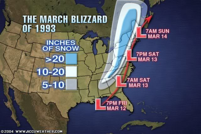
Everybody is buzzing about the winter storm coming around Monday next week. Some people are even comparing this possible storm to the Superstorm of 93. In case anybody don't know it. The above graphic demostrated what that storm dd. This system dumped more than 3 feet of snow to some selected places in its path. Is this a hype? or reality. Lets put things into perspective.
This system will take a similar track as the superstorm 93 did. Starting off in the gulf and traveling due north across the interior east coast. The low is forecasted to be 970mb by many models(comparing to 1000mb from this storm that effected us just before). This would mean the area getting effected will receive really heavy precip and super strong wind. Blizzard warnings are almost certain with a low this strong.
However. Will this happen? First of all. The track of this system is still iffy. If this thing takes a further west track. Areas around southwestern Ontario will get effected while southeastern Ontario will receive a messy mix or even a severe ice storm. If the track goes further east. Only eastern Ontario will be effect or even completely missing the whole Southern ontario region. Second of all, will the storm be actually this strong? We are have seen storms being forecasted by models turning into busts. We are already within 5 days and most of the models are agreeing with a strong system. The chance of this storm being as advertised is quite high. Although I think it may be a little weaker than originally anticipated(Or even stronger, like superstorm 93).
I am still in the wait and see time frame. We are still 5 days away and anything could happen. If indeed this storm will be the blend of all forecast models. This "superstorm" will be remembered for years to come. I will definately have more details tommorow and probably coming to my early predictions on how exactly this will shape up.
Tuesday, January 27, 2009
Update and Observations

Winter Storm Warnings had been extended and Extreme Winter Storm warnings had been issued for parts of eastern Ontario. General amount from the Windsor-Newmarket-Ottawa South will be 15-25cm with 30cm in the extreme eastern Ontario and locally in some areas.
Updated Forecast Amount for selected cities:
Toronto 19-22 cm
Hamilton 20-24 cm
London 16-18 cm
Windsor - 16-18 cm
Barrie - 10 cm
Niagara Region - 22-26cm
Kingston - 26-32 cm
Peterborough - 18-21cm
Kitchner/Waterloo-18-21cm
Guelph-18-21cm
Ottawa - 18-21 cm
Sudbury - 2-4 cm
Winter Storm Omar is the big one


Tuesday Jan 26 2009 9:00 AM EDT- A powerful low pressure system associated with crippling winter weather is heading to Southern Ontario. It is currently bringing significant snowfall accumulations and a killer ice storm in the central US. The mix bag is not expected to reach our region, but will see an ubandant amount of snow The failure to recognize the eventual northwest shift of the model continued to be displayed by Environment Canada and The Weather Network.In fact, the track of this system and its moisture is still continuing to shift northwest. This means a higher snowfall total for most of Southern Ontario. Snow should begin in Southwestern Ontario late evening and reaching the GTA just passed midnight. Snow should continue with a few minor breaks in between til late afternoon. Snow will be heavy at times and could hamper the morning rush hour badly. With the south easterly wind early in the system. Lake enhancement could be expected from Oakvile into Hamilton. Additional accumulations should be minor due to many areas in the lake being frozen. 15 to 25 centimeters of snow is expected for areas south and east of the chattam-Newmarket-Ottawa line with less accumluations northwest of this line. Winter Storm warnings had been issued for areas expecting more than 10cm of snow. This warning could be expanded and some parts could be upgraded to extreme winter storm warning as the situation continued to be monitored.
Forecasted Amount for selected cities:
Toronto 18-20 cm
Hamilton 20-24 cm
London 16-18 cm
Windsor - 15-16 cm
Barrie - 10 cm
Niagara Region - 20-24cm
Kingston - 24-30 cm
Peterborough - 17-19cm
Kitchner/Waterloo-17-19cm
Guelph-18-20cm Ottawa - 17-21 cm
Sudbury - 2-4 cm
This system is perhaps the biggest winter storm of the season. Maybe not for us, but for the generally eastern half of North America. This system had the biggest swath of of more than 15cm of snow and is bringing a historical ice storm to Kentucky, Southern Missouri, Illinois and Indiana.
It is really convenient how EC and TWN finally recognized this storm LESS than ONE DAY before the event. I've been calling for this system to trend NW ever since 3 days ago, it isn't until today that the major forecasters finally started calling it. This is truly some horrible forecasting.
Models are still trending NW and stronger as I speak and I can even see the forecasted amount upped later today.
This is all I have now and expect an update and a further detail later on throughout the day.
Monday, January 26, 2009
Forcast right on track, EC and TWN to fail again

After examining the latest models, I can pretty much say my forecast right now is right on par. The continued northward trend from the models cannot be stopped just as I speak.
Sadly enough, the twn major forecasters failed yet another time. I am currently more accurate than TWN 96% of the time and more accurate than EC 60% of the time. Things like this should not be happening especially consider they hire proffesional meteorologist. Just by putting out simple graphics with not even a trace of discussion and being wrong most of the time?
I seriously am planning to start a petition to tell them to take their job seriously, especially TWN. I know they can do better, but unfortunately, looks like all the care is the $$$ and not informing the general public of more accurate weather information.
The time frame of the system is also pretty much locked in. Look for snow to start after midnight Wednesday and continue throughout the day into Thursday.
I will issue my final forecast sometime tommorow and update on the latest indications in between this time.
Sunday, January 25, 2009
Winter Storm Oma Forms, Eyeing Southern Ontario


First of all, happy Chinese New Year to whom who celebrate it!
After Long period of quiet, the weather is finally stirring up again. What we have now is a slow and powerful, but a tricky winter storm to forecast.
This storm will be a tad difficult to explain but I will try my best
Originally 3-4 days ago, the GFS and Euro had a storm cutting the great lakes, giving mixing to most of Southern Ontario around the 29-30th. However, the last two days, the GFS had this system suppressed so much south that even major northeast cities misses this storm.
When the GGEM got into range, it had a complete different solution. It shows the main low cutting right up along the Southern great lakes, giving a significant winter storm to us. The GFS and the Euro now also is starting to trend this way. Instead of a storm coming around the we now have a huge bulk of moisture trapped under starting tommorow and will slowly move its way up. There is still so much disagreement with the models in terms of everything from the time frame, temperature and the track that it is best to wait it out to see how exacly things play out.
What makes this so difficult to forecast is the high pressure up in our area which is blocking this system from moving up. When, how and where these high pressures break down will be the key to how this system will turn out and that is exactly why there is so much disagreement right now. The map above demonstrate the two possible tracks this low can take depending on the change of the high pressure. The time also is key. There is actual two swath of moistures. The frontal moisture shown by the GFS and the moisture at the back along with the low shown by the GGEM. Both of these moiture bands are also key things to watch as this storm develops.
If this storm were to move in, this will be a classic big winter storm. It has the typical comma form and the fronts at the right place. Which means we are in for a very organized winter storm which typically brings 15-25cm with higher amounts possible.
The forecast snowfall map is what I think is gonna eventually happen, for the models disagreeing so much, I actual have some decent confidence in this map. Warning map with watches should be out tommorow.
this one is a very interest beast to watch and develope
Saturday, January 24, 2009
Its Quiet, Too quiet
I still remember the song I did for my speech arts competition back in grade 7, it goes something like this
sunny day and cold nights!
we had almost exactly similar weather the last few days and it looks to continue the next 4 days. sunny cold days with occasional flurries.
but things will change. A potential major system is in store around the end of the month. Though the models had not yet come together in agreement and this is still too far away, I think I can safely say a storm is coming.
Monday, January 19, 2009
La Nina returns, snowy second half, record snowfall projected
Youngsters' Weather Blog project a record breaking winter in terms of snowfall this winter
Snow continued to pile up yesterday and today from the lake effect and my area is now well above the winter average. Reports from NOAA suggest we are now in a moderate Nina, which dumped heavy snowfall after heavy snowfall second half of winter as last year.
With the first half of winter WELL above normal in the snow department, almost twice as much snow as this time last year. A second half similar to last year almost guarantee a record breaker. Well this happen? it is starting to look like a sure thing.
Cold air will dominate the rest of January, a storm or two may be on the way. Which could dump another addictional 20-30cm to Southern Ontario before the end of the month.
There may be a brief thaw at the beginning of Feb, as a ridge appears in the east. This could allow for some major melting/flodding in our region. Followed by a possible flash freeze.
However the reminder of the winter looks snowy to say the least, we might get hit by constant Colarado lows, which always dump 10-20cm with higher amounts possible if remaining on the snowy side.
There is already more than 50cm on the ground in a lot of regions in Southern Ontario. They aren't gonna melt any time soon. Even when it does, more snow is surely on the way.
These two winters really spoiled us.
Saturday, January 17, 2009
Winter Storm Nick a historical storm
This one is going straight to the record books for all time greatest snowstorm in the GTA , it was no surprise that many regions are gonna see 30cm of snow once the lake enhancement was noticed, but the problem is, NOBODY recognized this.
Snowfall total approaching 25cm here and 2 meter drifts can be seen in the back parking lot. Moderate snow continues to come down and should last another 6 hours before tapering off.
I was actually the first to realize the enhancement and quickly upped my amount forecasted. EC followed 6 hours later(yes) when places in the GTA is already approaching 20cm and TWN is just... forget it.
This will go down not only as one of the biggest snowfall but one of the biggest meteorological glitch. So much for those "expert" meteorologists of the 21st century.
Anyhow, enough with the ranting, I absolutely need to enjoy this storm!
Lastest statement for winter storm Nick
FORECASTED AMOUNT UPPED TO 15 TO 20 CM WITH LOCAL AREAS REACHING 25 TO 30 CM FOR ALL OF SOUTHERN ONTARIO. THE EXCEPTION TO THIS IS THE NIAGARA REGION WHERE THE SNOW AMOUNT WILL STAY BETWEEN 10-15CM
LASTEST INDICATIONS SHOW HEAVY SNOW EXTENDING FROM SOUTHERNWESTERN ONTARIO INTO SOUTHERN CENTRAL ONTARIO TONIGHT. 20-25CM OF IS ALREADY BEING REPORTED IN PARTS OF MICHIGAN AND WINDSOR IS ALREADY AT THE 10CM MARK WITH 5 TO 10 CM MORE TO COME.
S TO SE WIND IS EXPECTED TO CONTINUE TONIGHT WHICH WILL ENHANCE THE AMOUNT SE AND S OF LAKE ONTARIO. SOME ISOLATED AREAS AROUND THIS REGION AS WELL AS EAST OF GEORGIAN BAY COULD APPROACH A FOOT OF SNOW.
SITUATION IS STILL BEING MONITORED AND EXTREME WINTER STORM WARNING HAVE A CHANCE TO BE ISSUED FOR A FEW REGIONS MIDNIGHT TONIGHT.
Winter Storm Nick Forecast update

A Clipper diving from the Manitoba/Saskatchewan border is moving through Southern Ontario this afternoon into tommorow. A general 10-15cm is expected for all of Southern Ontario with higher amounts northwest of the GTA.
Snow will begin in Windsor this late morning moving into GTA by the afternoon. The bulk of the snow wont be over until Midnight when the snow will taper off.
Forecasted amount for selected cities:
Toronto 12-15 cm
Hamilton 12-17 cm
London 13-18 cm
Windsor - 10-13 cm
Barrie - 12-17 cm
Niagara Region - 8-13cm
Kingston - 13-18 cm
Ottawa - 10-15 cm
Sudbury - 4-8 cm
Friday, January 16, 2009
Next Clipper is winter storm Nick


What appeared to be a harmless clipper that could graze us with a couple of cm had turned into a winter storm. The modeled not only had trended it much further north, but with much more moiture as well.
This looks like a 10-15cm event for most of Southern Ontario with some regions getting 20cm.
So why do I can this Clipper a winter storm? There a few reasons behind it. The QPF of the system may not be as much as I would like, but the upper air temp as well as the surface temp is well below freezing, the snow ratio should be somewhere between 1:15 to 1:20. All the models came up with the same solution and the first few flakes of the system is set to arrive withing 12-18 hours. This give me a great confidence in my forecast.
I will issue an update for the warnings and forecast for selected cities tommorow late morning regarding this system.
looking further out. cold air should still be the main player at least until the end of this month
Another winterstorm could be around the doorsteps between 23-25th. Too early to talk about the track and amount, but I think a storm of some sort should get here around this time frame. I'll watch this as things progresses.
Tuesday, January 13, 2009
next clipper looks rather unimpressive, cold air is!

Brace yourself for a few very cold days!
heavy squall of Georgian bay and lake Huron sets up and could bring up to 15-20cm by tommorow to local areas.
The clipper that was set to move in tommorow looks rather an impressive, as the modeled significantly weakened this system. However, a easterly shift of the wind could bring 10-15cm to places in the Oakvile, Burlington region. Toronto could pick up 2-5cm with a little more west end of the city.
A system to watch around Saturday as yet another Alberta Clipper dips down south. This one is slow moving and 10 cm is definitely possible.
Our best bet for a major winter storm lies towards the 22nd to the end of Jan. As a pattern Shift could allow warm moisture to ride up the eastern US. However, we still have a long way to go. Cold air will dominate for the next 10 days with a slight break accompanied by snow this weekend.
Sunday, January 11, 2009
Clippers Continue to up snowfall totals

Toronto is already approaching the seasonal average and we could very well surpass it before even reaching the halfway of the winter. Two clippers will rumble across a region, bring up to 25-30cm in total for places in Southern Ontario.
The first one will arrive Monday overnight. With the intensifying trend of the models and the high snow ratio we are looking at. I think 10-15cm is not out of the question for many places. It could be as much as 20cm in some places north and east of Toronto. Very strong wind will follow which could result in blizzard like conditions once again.
The second one is the one to watch, with the models trending slightly north and with the snow ratio ration EXTREMELY high, I think this one have a lot of potential. I will certainly keep an eye on this. Also consider windchill values in the -30s while this clipper takes place.. YIKES
Next Clipper will bring snow and cold

The next Clipper is set to bring a widespread 5-15cm to most areas in Southern Ontario. Follow by the stronger cold air in years. expected values anywhere between -20 to -30 around th GTA at night with windchill possibly reaching -40
Friday, January 9, 2009
Warning Map for Winter Storm Michael
 Daniel had been doing a great job in filling in the information on this winter storm. I don't have much to add other than the fact that the models had been trending slightly north, meaning we could see possibly 5cm in Toronto.
Arctic cold will come right after and a even colder shot of air will arrive after another Clipper type system arriving Monday in Tuesday. More details on that later.
Thursday, January 8, 2009
Update on Saturday Storm and Long Range
My thoughts onthe weekend storm still remain unchanged.As I type the storm is in the praries right now and parts of saskatchewan are going to get blizzard conditions with this system.Enough of me rambling about what is going to happen in the praries as I have to focus on what impacts this storm will have for ontario.Latest model guidance suggests that this storm is going to be a little slower and move slightly further north than what I was thinking yesterday which means that the axis of heaviest snow will fall from a line from windsor to St.Thomas then through Niagara Falls where there could be 10-20cm of snow.Much more coming later tonight when the 00z Nam comes out and also I will detail the coming cold wave for next week.
Wednesday, January 7, 2009
Next Storm looking less likely
The storm that gave Toronto 10 cm of heavy wet snow is pushing of to the east and we are left with a hangback trough that will give us another 2-5 cm of snow.That leads me to talk about the next storm for friday night into saturday morning which this morning was looking like a major snowstorm with 10-20 cm however latest models indicate that this storm is going to be a no-storm for the GTA but simply just some light snow accumulating to about 2-6 cm by saturday afternoon.The models keep the bulk of the energy stateside where the center of the low will track across the ohio valley then out into the atlantic.The EURO/UKMET,and GFS have trended south with the system.The only model that still has the storm giving toronto decent accumulations is the NAM but I consider it an outlier right now as I expect it to shift south like what the other models are showing.What seems more and more likely is the arctic air coming down next week and right now the models are saying that toronto might have an afternoon high next wednesday of -15! Yikes.With this type of pattern setting up I expect that there will be some pretty hefty snowsqualls in the traditional snow belt areas and some areas could have over 2 feet of snow by the end of next week.Well time to go ypoungweatherman and I will continue the update the blog over the next couple days on the so-called storm for saturday.
Tuesday, January 6, 2009
Winter Storm Leon Final Forecast

A winter storm is currently moving in to Southern Ontario. The models had finally came to an agreement this close to the system and a general amount of snow is already set. This storm will produce a variety of wintery weather for Southern Ontario. 8-10 cm is expected for Southwestern Ontario changing into Freezing rain later overnight. 10-20cm is expected for South Central Ontario While 20-30cm is expected for South eastern and parts of central Ontario. The primary low of this system is expected to linger in the area longer and the duration of this system looks to be extended, thus the increased amount in Southeastern Ontario. Driving conditions will be terrible throughout Southern Ontario tommorow as a variety of wintery weather can cause many problems.
Forecasted Amount for selected cities:
Toronto 12-18 cm
Hamilton 10-15 cm
London 8-10 cm
Windsor - 5 cm
Barrie - 15-20 cm
Niagara Region - 10cm
Kingston - 15-25 cm
Ottawa - 22-30 cm
Sudbury - 12-17 cm
It is amazing how this storm is turning out like what I thought it would 4 days ago. It was definitely a fun storm to forecast.
It almost seemed like EC reads my blog, right after I complained about the amount they forecasted, they upped to 10-13 cm for Toronto! No warnings had been issued but it is definitely a good sign that all the models and forecasts starts to come into sync.
here is a timeline of what to expect in the GTA
midnight- light snow begins
midnight to 3am - moderate snow bands move in, 2cm on ground
3am t0 8am - snow at times heavy mixed with ice pellets, 5cm on ground
8am to 1pm - snow turns wet and light, mixed with ice pelletes and freezing drizzle 6cm on ground
1pm to 6pm - snow turns moderate again and continues to fall throughout the time frame, 9cm on ground
6pm to 10pm-snow at times heavy will get lighter throughout the evening 12cm on ground.
10pm to overnight- moderate to light snow 14cm on ground at the end of the period.
This storm will be quite long lasting as you can see as the low will stall around our region tomorrow.
Another snow storm will be moving in Friday night into Saturday for southern Ontario, this system will initially be a strong clipper, it will draw some moisture from the south by the time it gets to Southern Ontario. Most of Southern Ontario looks to be getting at least 8cm of snow possibly up to 20cm in some region. (GGEM shows 18-22cm right now). I will have more details on this and the complete forecast tommorow.
EC prepares to eat crow?
The recent updates of all the models actually look very good. GFS had shifted the amount slightly less, but both the NAM and RGEM had increased the QPF dramatically. Storm is also developing nicely on the radar. I still think we are looking at 10-20cm of snow in the GTA and EC is forecasting 4-6cm. Unless they change the forecast in the next update(which is 15 minutes away). I can see them seriously eating some crow.
My final forecast will be out in about 1 hour.
My final forecast will be out in about 1 hour.
Monday, January 5, 2009
Dissagreement between models causing confusion

While the storm has not changed much, there is one particular outlier which is doing alot of annoyance to forecasters. The Nam continues to bring very little moisture to the North side of this system. Giving perhaps only 5cm to Toronto and even less for Southern Ontario.
While this seemed to be an unlikely senerio. I would still like to hold on a bit before making a final call. My current thought still remains as 10-15cm for Southwestern Ontario(5-10 for Windsor area) 15-20cm for the GTA and 20-30cm for Eastern and parts of Central Ontario.
The system is developing quite nicely right now in Southern US, showing a huge swath of moisture. The low will move Northeast then North up towords Ohio later tonight into tommorow and snow should start around the shores of lake Erie in the evening. The storm currently looks more moisture laden than the modeled had showned. Whether this will translate into snow for our area is still needing to be determined.
My final call on this system could be delayed until tommorow afternoon
Sunday, January 4, 2009
Winter Storm Leon forms, Significant accumulations expected

 Sunday Jan 4 2008
A strong low pressure system is set to bring wintery weather to all of Southern Ontario Tuesday Night into Wednesday. The main bulk of moiture will move north and phase with another low pressure from the west, bringing a complex and powerful winter storm. The centre of the low pressure system will be quite strong, and will moving directly along the Southern lakes. a general 15-25cm with locally higher amounts are expected for most of Southern Ontario with slighly less amounts to the extreme south along the shores. Strong wind will accompy this system with wind gust exceeding 50km/h. There are still three more days left until the low pressure system arrives and some minor changes should be expected to the final forecast. This system will be a slow mover and have the possibility of exceeding 24 hours. Winter Storm watches are issued for most of Southern Ontario. Stay tuned for further details as the storm draws nearer.
It is the last day of the break for me before school starts again and this day will be quite busy. I got a novel to write, a website to run and now an exciting storm to forecast.
Over the last day, there are some slight wobbles with the models, but my main thoughts on this system remains unchanged and I have the exact forecast in mind this time yesterday. It is good to get this consistency.
Wishcasting is a very bad label among us weather nerds, but unfortunately I see alot of "indirect" wishcasting among many in the forums. Some people in the US northeast forum always claim that there forecast have no wishcast what so ever( even their blog name suggest that). But when countless big storms you forecast turn to nothing and you use anything possible to prove that a big winter storm is eminent when all the evidences are against you. I'm sorry, but that sounds like wishcasting to me.
The irony behind that is when someone from other regions point that out, they got labeled wishcasting instead. It is a funny double standard.
Yes I am calling out a few people here, not gonna mention the users but you know who I'm talking about.
Enough with my complaining, lets get on with the storm!
Like I mentioned previously, I am quite satified with the models right now. A little wobble here and there by all of them but not nearly enough to change the track I have in mind. Snow should begin in the windsor Tuesday evening and slowly progresses overnight. We shall not see the end of snow at least until Wednsday overnight and by that time, strong lake effect bands already set up through many areas.
Forecast discussions thread will be set up tonight and final forecast with warning will be out Tuesday Morning.
Saturday, January 3, 2009
Another winter going to the record books?
It will be quite something if 2 record breaking winter occurs in a row, and that is what we might be looking at!
Nov and Dec had seen a total of 70-80cm of snow, which meant we are on pace for a 210-240cm winter! Of course, that is assuming we keep this up and as far as right now is concerned, we definitely are!
The storm which I mentioned yesterday continues to develope. All the major weather models had already agreed with a low centred around the GTA(yeah, you heard me right). Usually, this mean we are looking at an icy/rain storm, but since this one is coming directly from the south as a Texas low, the cold air coming from the north west should keep us mostly snow if not all.
The low pressure centre looks to be quite deep. Droping below the 990mb mark and quite possibly reaching the 980 mb mark.
The system is also a slow mover, which means we are in for 24+ hours of on and off snow. The moiture does not yet look very impressive, but I think that will come and 15-25cm is not out of the question.
With the shift to more of a westerly track, the chance of mixing increases, but as the track stands now, that risk will still remain to the extreme Southwestern Ontario.
Winter Storm watch will be issued for parts of the Southwestern Ontario tonight as well as the primary forecast. That map will slowly expand tommorow and warnings will start to come out Monday night.
With all that excitment, I almost forgot to mention the freezing rain event that we shall see tommorow. The amount looks to be minimal but whenever you are dealing with ice, things are always effy. I will advise most people not to drive tommorow in Southern Ontario.
With that, I would like to conclude that this looks once again be one snowy winter, whether we will be near the record, lets find out!
Friday, January 2, 2009
A Texas low brewing

The next few days will be a tad disappointing.
What originally looked like two storms withered away. Leaving us with a few flurries last night and some light ice coming up. However, a much likely storm threat is coming up.
This swath of moisture looks to be coming off Texas-Mexico Border, joining up with some colder air and another low pressure from the west. The senerio we are looking at is a low pressure system tracking up into the Ohio valley.
The previous models show the stronger low going off the coastal regions, however, most of the recent models(GFS, Euro and GGEM) is bringing this thing back. The Euro does not show a coastal low at all and the other two should a stronger in-land low.
When models start to come together around the day 4-5 period, it is always a good sign. I usually don't call amounts this early, but I will say 15-25cm with more possible seems pretty likely at this time.
The mixing and rain threat for this storm does not seemed to be too high. Unless the models start a warmer trend from now on, the only areas prone to mixing is near the southern lakes(as usual). There is a big dome of arctic air to our North and west. I don't see that being pushed away easily at this time of the year.
I think I will have a much better grip on this storm on Sunday and expect my primary forecast and watches to be issued Sunday night. I will have an update tomorrow.
After this storm, we will be in for the coldest arctic air of the season. We could get into our first -20 below in a while! It looks like it will be the best shot at some record breaking during the 6-14 days time frame.
Subscribe to:
Posts (Atom)
