Sunday, November 30, 2008

Daniel Goes Northwest, snowstorms turns icy


Latest indications show the storm with more northwest track, temperature will hover around the freezing mark in all of Southern Ontario. Mainly Snow is expected north of London, GTA and Kingston.

Final Forecast

Windsor - 5 cm
London - 10 cm
Toronto - 5 cm downtown, 10 cm suburbs, 15-20 cm North of highway 7
Barrie - 20-25cm
Niagara Region - 2- 5cm
Kingston - 2-5 cm
Ottawa - 15-25cm
Sudbury - 15-25cm


Due to time restraint, there wont be further discussions about the forecast and observations will set up in 30 minutes. Many places in Southern Ontario already started to report snow. Stay tuned.

Saturday, November 29, 2008

Winter Storm Daniel Forecast discussions

10:00 AM - models had made a shift, for the worse and the radar aren't looking very promising either, it looks like it will be warmer than expected....

10:00 PM - Did not update for a long time, but I have lots to say right now. Models are showing a stronger storm each solution. Temps will be at or below 0 north from London to Newmarket to South of Ottawa and temps will be slightly above 0 anywhere. This makes the forecast very tricky, especially that the freezing line on the GFS sits right above lake Ontario. I still don't believe there should be too much rain anywhere North of 401. Should be either wet snow or snow. If it stays all snow, we are looking at 15-30 cm here in lots of places in Southern Ontario. Things will not be very pretty though, temps will be constantly above the freezing mark for the next several days. There will be many shots of cold air afterwards but they do not seem consistent on the models, which could mean a continuious stormy pattern.
Final forecast out tommorow. I think I should get a much better idea of what exactly is gonna fall where soon. I have stated earlier that this storm will be mostly snow or nothing, still sticking to that statement.

10:00 AM - gonna be a short forecast discussion this time, final forecast out early tomorrow afternoon. As of now, the GFS and NAM is starting to look better. If the temp goes 1-2 degrees Celsius, this will be looking very good, still sticking right along with my original forecast.

Friday, November 28, 2008

Winter Storm Daniel Primary Forecast


3:00 PM EDT Friday Nov 28 2008-

An Alberta Clipper is set to move down South into the US plains assoicated with a low pressure system is set to move Northeast into west of Apps
Another gulf set of moiture assoicated with another low is to set to move north along the Atlantic coast. This is a very good set up for a winter storm
that would arrive late Sunday in southern Ontario.
Dispite recent models suggesting a warmer and weaker system, due to the forecasted conditions during this time period, the recent models are considered
as outliers. There is a strong confidence a winterstorm of some shape will take place and will bring significant amount of snow to parts of the Southern Ontario.
Current anylises suggest that this winter storm will produce 15-25cm of snow to most parts of Southern Ontario and 5-10 cm of snow to Southern edges closer to
the lakes due to rain mixing in and the wetness nature.
There are still a few unknowns and the recent NAM model raised that question further, situations will be monitored closely and the final storm forecast
will be issued Sunday Afternoon

Windsor - 10-15 cm,
London - 15-20cm
Toronto - 15-25cm
Barrie - 20-25cm
Niagara Region - 5-15cm
Kingston - 5-15cm
Ottawa - 20-30cm
Sudbury - 5-10cm


Oh what? this is the forth winter storm already???? sure it doesn't seem like it here in Southern Ontario, but many folks out there already got their taste of winter. Now, it looks like we will be getting our's.

I was very happy that the models where fairly consistent yesterday but I was in half-shock how the models starts arguing again today. Like I've mentioned previously, I would not pay too much attention to what the models are doing until tomorrow afternoon.

Despite the fact that the models kind of did a flip, they still all shows a snow storm for Southern Ontario, which again varies the legitimacy of this system. Temperature will once again hover around the freezing mark which is always tricky.

It was very surprising how everybody, even the very conservative agencies, jumped onto this storm early. EC issued a special weather statement yesterday, no you didn't read it wrong, 3 days out, Michael Kuss of CP24 even mentioned this storm 5 days out. When professional meteorologist starts to jump onto a storm this early, you got to pay attention to it.

I fully expect the models to have a fair agreement of decent accumlating snow(10+) for most of Southern Ontario tomorrow, we shall see. but for now, I am pretty confident with the forecast I have now.

PS: I see a very strong surge of cold air around Dec 10th, details on that after this storm

Thursday, November 27, 2008

Winter Storm Possibility Nov 30-Dec 1


After much thought and consideration, I think that a winter storm will definitely take place between the time period indicated. Though many have different ideas, all models point towards a storm centering the low somewhere around the Northeast and the Coast. The GFS also indicated a secondary low forming as week.


There is still alot of unknowns left for this storm but I think this one will be easier to forecast than the last storm once we get into the 3 day range. As of right now, I think the heavest swath of snow will stay around the Canada/US border with the low tracking east of the apps. I will give the models a day or two to make up their mind on the exact track.


I've been emphasizing that it will be either mainly snow or no storm at all for southern Ontario, and I have a strong case for that. With the cold arctic air set to arrive at this point, a neutral Enso and with the NAO set to plunge, it should be a good set up for a coastal storm. One key thing for this is missing is the high pressure system that should set up across Northern Ontario. This let me to believe that this low have a high likelyhood of tracking east of the apps, generally, storm like that gives us 10-15 cm of snow with the heaviest staying a little south of the border across Northern Ohio and Upstate New York.


However, with still 4 days left and lots of things to be settled, this storm will only remain a possibility for now. Lets see how this thing will eventually work out.

Wednesday, November 26, 2008

Winter Storm Christine leaves frustration behind, cold/ stormy pattern continues

When this storm had appeared on radar, I know that it is gonna be a tough one to deal with, the models are leaning one way or another and I have to take a central stand, turns out that is what happened.

Since Monday Afternoon, about 10 cm of slushy wet snow had fallen in Toronto, you wouldn't be noticing that if you look outside. All but melted either on contact or soon after. Folks just north of the GTA got a decent storm out of it. Aurora got 10-15 cm and Barrie got 15-20 cm, most had been sticking to the ground.

In terms of the overall accuracy of my final forecast, it is actually pretty good. The only part I probably messed up is around the golden horseshoe.

I am still waiting for the final amount and should have a report on that by tomorrow in this thread.

I really don't like looking into the past, especially when its not very good, so lets have a quick looks at what the next little while looks like.

like I've mentioned previously, we are currently in a very interesting pattern.

lake effect should continue off Huron, Georgian and Erie and amounts could be disastrous yet again. This Nov and Dec could very well get most of the snowbelts above the annual snowfall average.

The past 3 days had a storm moving up in the northeast on almost all major models. The Euro brings the storm right to us. GFS and GEM had it into the coast, guess what, it looks like the Euro had persuaded the GFS and GEM to join its idea and on the 12z run this morning, all have a major winter storm going up.

the be quite frank, the 12z GFS is making me drool, 50 cm of snow with blizzard conditions for the GTA. I seriously doubt that this will ever be the case, but it just shows that there will likely be a storm at this time range, especially when all models agree somewhat this far out.

I would love to get out the storm possibility post out right now, but it just don't seem realistic to jump on the gun on something that just caught people's attention, I will be monitoring this one very closely as always.

Winter is here to stay!

Monday, November 24, 2008

Winter Storm Christine

5:00 PM EDT - Steady Wet snow had been falling since 2:30, but unfortunately, due to the warm temp and the wetness of the snow, nothing is sticking. Still interested in why in the world isn't forecasts picking up the backside snow.

Sunday, November 23, 2008

Winter Storm Christine Final Forecast


8:00 PM EDT Sunday Nov 23 2008
A low pressure system combined with gulf moiture is set to turn into an interesting winter storm
and move into Southern Ontario on Monday Afternoon. The track of the low is 50-75 KM south of the
orignal forecast position as of 7:00 PM EDT while the models have a consistent track for the next
24-48 hours. The first wave of the storm will enter windsor late in the morning and arrive in
Toronto be the afternoon, precipation should first begin as rain snow mix and will gradualy change to
snow late evening and overnight. I am confident that the precip will stay mostly snow in most areas
in southern Ontario other than the far southern regions. a general swath of 5-10 cm is forecasted
for southern Ontario and 10-15 cm for central Ontario.
There will be a break early Tuesday morning and precip will pick up again in the afternoon
The second wave will be alot more trickier. The low pressure system will transfer the energy
into the coast, and will slowly go inland again, the low could stall there for up to 36 hours
around the NY, PA and ON border. Recent US models brought moderate to heavy wrap
up band to Southeastern Ontario extending all the way into the golden horseshoe, lake enhancement
will also set up across Huron, Georgian Bay and Erie. After examining many references, the conclusion
is a general 5-15 cm of snow from Tuesday Afternoon to Wednesday Eve for most regions in
Southern Ontario. Flurries could last up to Thursday.
The snow that will come from this system will generally be wet and heavy, lots of snow could
melt on contact, slushy and slippery condition is expected all through Southern Ontario.

Forecast for selected locations

Windsor - 5 cm, start off as rain, snow will get mixed in later on. Minimal amounts for Tuesday and Wednesday
London - 15-20cm, start off as mix, turns into wet snow late evening. Break early Tuesday, snow starts again by afternoon
Toronto - 15-20cm start off as mix, turns into wet snow late evening. Break early Tuesday, snow starts again by afternoon
Barrie - 20-25cm Snow into Tuesday Morning, snow starts again Tuesday Afternoon
Niagara Region - 10-20cm rain-snow mix into wet snow overnight, snow starts again Tuesday Afternoon
Kingston - 5-10cm Rain-snow mix starts late afternoon ends late morning, rain or snow starts again Tuesday afternoon
Ottawa - 20-30cm Snow starts in the evening, turns into rain-snow mix Tues After, switches back to snow late evening
Sudbury - 15-25cm Snow from Monday eve into Wednesday


It took quite a bit of overactive brain cells to go through the last few days, the models been doing double takes on the storm. One of the best consistency I've seen on the first wave, and quite alot of bickering on the second. I am able to come up with a conclusion nevertheless, and I am pretty confident that this will be the track.

Rain snow mix should start in Toronto by the afternoon hours and the rush hour traffic is going to be a mess with the slush. This part is almost guaranteeing 5-10 cm to most parts of Southern Ontario and it will all be very messy( not the nice and fluffy kind, ah that sucks).

When the coastal low gathers and moves inland, this must be causing many meteorologists headaches(hello Brett? probably why he still didn't come up with a forecast). The bulk of energy will be suffered by Southern Quebec and Southeastern Ontario, the places near the lakes and East of Montreal probably gonna suffer alot of rain. A little North you will probably find Ottawa enjoying quite a snowstorm out of this.

The wrap up band should(emphasizing on the should) pack something to Toronto, not only will this bring a general good amount of snow, this should also set up the already active lakes( a meter of snow for Exeter anyone?).

Anyways, enough with the talking and lets enjoy the first major snowstorm of the season!( or will we?)

Observation post will be open tomorrow afternoon and extending all the way to Wednesday, I will be actively updating on the latest information and hope all of you could provide something in the comments section.

Saturday, November 22, 2008

Winter Storm Christine Forecast Discussions

Sunday
5:35 PM EDT - the 18HZ GFS backs it up, this will be the last update before my final forecast in 4 hours. I will be looking at many more data before I get the final o

4:00 PM EDT- the 18HZ NAM is starting to lean towards the 12HZ GFS, giving a decent backdoor snowfall amount for the first time on this storm. ZOMG , could this be happening? blink.gif

2:10 PM EDT -
.....ah I wish! It will take more than a model run to make a dream into reality.

2:00 PM EDT - the recent GFS brough heavy backside precip yet again, this just made the forecast that much difficult, unless I got the confirmation from other models on the next two runs, I'm considering that an outlier. My final forecast is out in the evening.

Saturday
1:00 PM EDT - I am getting a better idea of what is gona happen, models are starting to come together and tonights 00hz runs are very important. It looks like the first wave should bring 5-10 cm of wet snow mixed with ice and the second wave should bring another 10 cm to Toronto, the amount will be less west of Toronto and more east of it.

9:00 AM EDT - Not much changes right now in terms of my thought. The models have been pretty consistent themselves but not with each other. The NAM still don't show the second wrap up and the GFS continues to bring it up, I am and will slide with the NAM for now.

Friday, November 21, 2008

Winter Storm Christine In, Situation got alot more complex


6:00 pm Friday Nov 21 2008
Current models show an Alberta Clipper associated with a low pressure system is set to move right into the great lakes region by Monday Morning, this will tap the gulf moisture from south, resulting in a very interesting setup for the next 2 days. The initial low will move across from lake superior into the heart of southern Ontario, the draw of gulf moisture as a result will produce wet snow, cold showers and icy mix. Most parts of southern Ontario will receive mostly snow and wet snow. Things get interesting as the energy from this low transfers to the Mid-Atlantic Coast at Monday evening. A even stronger system with added moisture turns Northwest into PA and NY. Some model forecast the low pressure system to stall over that area, which could produce significant amounts of wrap up snow for Southeastern Ontario and Southern Quebec. This is very early into the game and lots of things can change, the only confidence right now is the track of the initial low, stay tuned for forecast discussions and final forecast over the course of the next 3 days.

Primary Forecast Amount:

Windsor - 5-15cm
London - 10-20cm

Toronto - 15-25cm

Barrie - 20-25cm
Niagara Region - 10-20cm

Kingston - 20-35cm

Ottawa - 30-40cm

Sudbury - 15-20cm


I was looking at the GFS model earlier today in my computer science class(yes, I know I shouldn't be doing that!), I am mildly pleased when I see that the storm track of this low is consistent, as I turn to look at the Monday night to Tuesday model, something caught my eye. The expected tranfer into the coastal low took place, but.... WHAM! the model brings the low inland and make it stall there! The QPF was amazing, pointing to 15-25cm of additional snow for Toronto and even more for East of me, I was totally astonished by this solution and don't really know what to expect.

When I got home, I started to look into more details. I am growing confident as the 18 hz GFS brings the same solution. Winter Storm Christine will take place and it looks like it will be much more than what I originally would expect.

However, I am not completely sold into this just yet. One simple reason is the time. We are still 4 days away from this, with the consistency of the original low, it looks like a Winter Storm will take place, but as for the low stalling, it is still a wait and see game. So far though, we know three thing will take place:

1. The Clipper coming down, draws moiture from the gulf, forms winterstorm Christine.
2. Moves into southern Ontario, brings mixing and 5-15 cm of accumulations
3. The original low will teleport from southern Ontario into the Mid-Atlantic

After that the guessing game starts, will it track inland and stay there as the gfs model say?

I personally will not jump the gun yet, this could very will turn into a bust simply due to the constant changes of the models especially when the low pressure isn't on the map yet. My gut tells me it will be a disappointment, put who listens to guts anyways? :P

I along with many others will pay close attention to the development, I will shortly examine what most other models say about this system. I will start the forecast discussion post tommorow morning and I would love to hear your inputs and thoughts. Hang on tight though, because the rollercoaster ride starts now!

As for the answer to the original question, a simple cliche: Only time will tell!

Thursday, November 20, 2008

Clipper Brings delightful amounts, winterstorm on the horizon


I am delighted when I woke up yesterday morning seeing 8 fresh cm on the ground, the Clipper had slightly overperformed many original forecasts. There are a few more heavier bands moving across the GTA after 11:00 pm, and is able to bring the total amount in my area to 8cm.

Squalls had already started west of London, accumulations could get heavy with up to 30-50 cm in effected areas. London will mainly miss the heavest part, and will see 15-25cm out of the squalls come Saturday evening.

I'm no expert in lake effect snow and you should refer to someone else if you want to know the exact set up of the lake effect the next several days.

Another Coastal low is set to meet Nova scotia then Newfoundland, their is the potential of 15cm -20 cm in Halifax and even more in rural areas. Due to the large amount forecasted for Halifax, this low is now official named winter storm Brian. I will probably have a map out for this winterstorm tommorow

we are entering a very active pattern the next three weeks.


Models is consistantly bringing a Clipper down to southern Ontario, Clashing with some warm gulf moisture coming from south. This is a very good set up for a winter storm and is exactly what I am going to focus on for the next few days.

Since this is early into the winter season, whenever we get gulf moistures, we will probably not gonna see all snow. Temperatures will hover around 0-4 degrees when this low phases and gives us a visit, things such as ice pellets and freezing rain is definitely not out of the question.

This low will travel through the upper lakes, departs once the gulf moiture is up and transfers to the coast, and will ride up inland, resulting in a possible big nor'easter for the Atlantic Provinces. People in the Northeast Apps should receive mixing and some decent amounts, but the folks closer th the coast probably will get all rain

This is still early and is only a potential, so keep that in mind there may be lots of changes. I will be monitoring this one very heavily.

this small clipper brough decent amounts for the folks in the GTA, but this will be the first of much more to come!

Wednesday, November 19, 2008

T-Dot's First noticible accumulation of the season Observations

11:00pm EDT - Snow is slowing down and the intensity level is dropping, got 6 cm for now and I think we will end up with 8 cm tommorow morning. Areas just west of Toronto could get 12cm. Gonna take a few more photos in the morning. The next storm on the horizon may be sooner than you think, I am currently watching something happening between Nov 24-26, a Clipper could be phased with some gulf moiture and could be the key incredient to the first major winter storm of the season. I will have the details of that up tommorow.

9:45pm EDT - Moderate snow coming down steadily now, accumulation nearing 5 cm. Radar shows no let up in at least 2 hours

8:30pm EDT - After the dryslot half an hour ago, snow picks up and gets heavier. Now falling at the heavest clip so far. 3 cm on the ground

6:30pm EDT - their is a dry slot west of Toronto right now and should move in 30 min or so. Guelph and Kitchner stopped snowing a while ago and should return shortly. Right now their is around 2 cm in Toronto

5:00pm EDT - Light to moderate snow coming down steadly 1 cm so far. The snow amount looks more promising than previously, due to the early start and the steady snowfall. I would make a small adjustment and say 5-10 cm for the GTA and close to 10 in the NIagara region and west of Hamilton

4:00pm EDT - Started to snow 1 1/2 hour ago, intensity is light-medium with flakes, ground is starting to whiten up. Isn't very reflective on the radar due to the small snowflakes. 1/2 cm accumulations thus far.

Tuesday, November 18, 2008

Strong Clipper brings the first snowstorm of the season

6:20pm EDT 0 Tuesday Nov 18, 2008
An Alberta Clipper will track through Central and southwestern Ontario Wednesday evening. Bringle a broad range of 5-10 cm with upwards of 15cm of snow to most places in central ans southwestern Ontario. This Clipper had been very consistant on the models and there is a strong confidence in the track of this system. Snow should begin tommorow afternoon in central Ontario and tommorow evening in the GTA and the Niagara region. This system will bring the first snowstorm of the season to the none snowbelts regions and another new shot of even colder air and lack effect snow behind it.

Windsor - 2-5 cm
London - 8-13 cm
Toronto -5-10 cm
Barrie - 6-11 cm
Niagra Region 8-12 cm
Kingston - 1-3 cm
Ottawa - trace
Sudbury - 3-6 cm

The winter chill looks like its here to stay and now it looks like it will be acompanied by a snowstorm.

Usually when tracking a low pressure system, it is always good to see consistancy. Its been amazing how consistant this Clipper had been shown on the models. For 7 straight days, the GFS shows this Alberta Clipper consistantly with a similar track into southern Ontario. It is one of the rare moment that a model is this stubborn on a storm!

I think this Clipper will bring at least 3 cm of snow anywhere west of Bellvile and East of Detroit. A strong band of lake effect snow will immediately set up after the system diminishes across Georgian Bay. Areas west of the GTA to London cold see upwards to 15 cm.

I usually lose bets, but I am soo very confident that this will bring accumulating snow that I even said to take my friends for dinner if it doesn't!

This is no big winter storm, but I think this moderate Clipper could cause lots of traffic havoc in the GTA due to the fact that this is the first snowstorm of the season.

This is a very easy one to forecast and definitely a good start to winter!

PS: the supposedly winterstorm on 22-24st I discussed on the previous post is nowhere to be found the last two days on the models, unless this thing show up tommorow, I will dismiss it.

Sunday, November 16, 2008

Clippers Racing Through

When I was walking to the library today morning, I've noticed a chill that I haven't seen in a while, winter Chill. The Wind is gusting those squalls as they came down once every little while, giving the winter like view outside. The only thing that doesn't look winterish is the ground, the snow from last night all melted away in a hurry.

The next two weeks are gonna get VERY interesting.

The cold front which brought us winter like conditions and snowsqualls is also gonna open up the lane for the Clipper parade( Santa Claus parade is today in Toronto). The first Clipper which had already arrived, is moving south of us, we could get a few burst of heavy snows overnight tonight and tommorow morning but not gonna see significant amount, probably 1-3 cm. The snowbelts are very active today and for the next several days. Them people Northwest of Toronto alright received 10-15 cm from yesterdays backside storm(compared to 2 cm in Toronto) and is reiving an additional 10-30 cm from the squall today and tommorow.

The second clipper is a bit more interesting, its been on the models for 5 days now and the track haven't changed much, there is also a bit more moiture with this clipper and the latest models shows a direct hit in southern Ontario. We could see 3-8 cm in south central to southwestern Ontario. I will be monitoring this one closely.

What I am really hyped up about is a storm showing on GFS a week away. This storm was shown as a monster that will bring 50+ cm of snow to southern Ontario 4-5 days ago, it reappeared once again(this time its not that strong though)! I however would not jump on the gun yet, it is only one run of one model and the track could be very different a day from now, and it will go back and furth until it reaches the 48 hour range. It is definately something to watch right now.

For now though, lets all enjoy the parade of Clippers! :)

Saturday, November 15, 2008

Winter Starts on Two Fronts!

It is your typical Mid-November shift, when quiet autumn weather suddenly turns into harsh winter patterns. This usually serves as a sneak preview of the winter to come, lasting a week and a return to fall again. This time however, when winter finally strikes tonight, it is here to stay!

This year, winter will start for folks in Southern Ontario in two waves, one wave brings the temperature down with some slushy wet snow. Allowing the second wave, an Alberta Clipper, to bring slight accumulations, frgid conditions and lake effect snow.

Wednesday, November 12, 2008

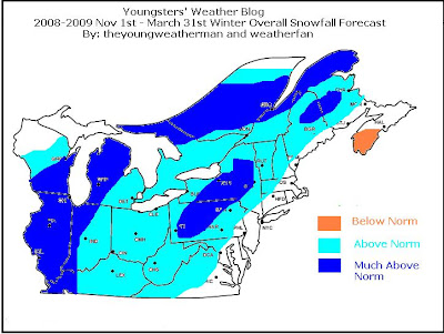
Final Winter Forecasts


Guys, sorry about the rushed post and the delay of the forecasts, I am very busy the last two weeks with my newly created website. I would not put any further discuissions about this and concentrate on the storms ahead. Apologies.