Saturday, January 31, 2009
Why the big change in the models?
There has been alot of talk on a potentially near-historic storm affecting many in the east,however as of thursday afternoon most if not all of the global models went drasticaly east and weaker.The models yesterday still showed a more easterly trend taking the storm of the east coast giving the I-95 cities a major snowstorm.So to the question now Why did the models change so big?. Well the answer is the jet streams.When the models wre showing a negitively-tilted deep storm slamming southern ontario with heavy snow that was the result of the northern branch and the southern branch of the jet stream phasing together,however now it is looking likely that we are going to see a less phased storm meaning that it will track east of the apps or near or along the east coast.I am not ready to throw in the towel just yet I'll give it till sunday night.If anything changes YWM and I will keep you posted.
Friday, January 30, 2009
Hype and Disappointment, blame the models
We are knows the story. Ever since 00z run of models yesterday, a big deep shock and depression downed at snowstorm loving folks in southern Ontario. A dramatic shift to the east of almost all major models.Followed by confirmation throughout the day.
We all know the tendencies of models around this time range, flip and flop. What constitute a good forecast is forecasting what is gonna happen, instead of forecasting what the models are showing or what the models are gonna show. People fall victim to that unfortunately, and that includes meteorologist.
Lets break down the dynamics of this storm. A deepening low off the gulf, stalling and sliding east before moving along the coast. Even before the model shift, we all know there is three scenerios with this system as I mentioned in the previous post. Looks like the senerio of this system moving west of us is almost nil while the scenerio that gives us the best chance of snowstorm still remains. The recent models tend to let the low travel out on the coast. Missing most if not all of southern Ontario.
I think this kind of track would be likely. We all know storms this year never do that. It will either get supressed out to sea or move further inland, and the further inland track definitely seemed more probable.
I think we will see the storm back in the models within a few more runs along with negative tilting action, but which place will get the brunt of the snow is still to be watched. A 50 km shift will do alot to the storm, and this thing looks to go down the wire. The bullseye of the storm is still anywhere from Toronto to Montreal at this point, with western Ontario on the outer edge.
The most likely track which I think would be is for this system to travel Along DC coast, but brings inland as it reaches the tri-stae area. It will cut north into the eastern end of lake Ontario. This track will bring the most snow to Kingston/Ottawa with decent amount of snow Toronto east and Quebec city west.
The storm is being too much overhyped, but the possibilities are still out there folks.
Thursday, January 29, 2009
SUPERSTORM coming, hype or reality
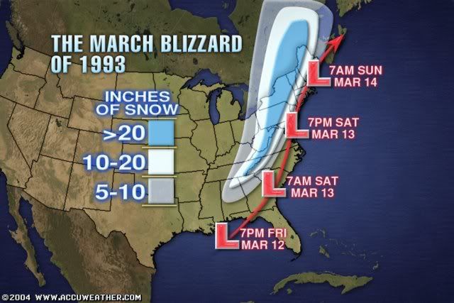
Everybody is buzzing about the winter storm coming around Monday next week. Some people are even comparing this possible storm to the Superstorm of 93. In case anybody don't know it. The above graphic demostrated what that storm dd. This system dumped more than 3 feet of snow to some selected places in its path. Is this a hype? or reality. Lets put things into perspective.
This system will take a similar track as the superstorm 93 did. Starting off in the gulf and traveling due north across the interior east coast. The low is forecasted to be 970mb by many models(comparing to 1000mb from this storm that effected us just before). This would mean the area getting effected will receive really heavy precip and super strong wind. Blizzard warnings are almost certain with a low this strong.
However. Will this happen? First of all. The track of this system is still iffy. If this thing takes a further west track. Areas around southwestern Ontario will get effected while southeastern Ontario will receive a messy mix or even a severe ice storm. If the track goes further east. Only eastern Ontario will be effect or even completely missing the whole Southern ontario region. Second of all, will the storm be actually this strong? We are have seen storms being forecasted by models turning into busts. We are already within 5 days and most of the models are agreeing with a strong system. The chance of this storm being as advertised is quite high. Although I think it may be a little weaker than originally anticipated(Or even stronger, like superstorm 93).
I am still in the wait and see time frame. We are still 5 days away and anything could happen. If indeed this storm will be the blend of all forecast models. This "superstorm" will be remembered for years to come. I will definately have more details tommorow and probably coming to my early predictions on how exactly this will shape up.
Tuesday, January 27, 2009
Update and Observations

Winter Storm Warnings had been extended and Extreme Winter Storm warnings had been issued for parts of eastern Ontario. General amount from the Windsor-Newmarket-Ottawa South will be 15-25cm with 30cm in the extreme eastern Ontario and locally in some areas.
Updated Forecast Amount for selected cities:
Toronto 19-22 cm
Hamilton 20-24 cm
London 16-18 cm
Windsor - 16-18 cm
Barrie - 10 cm
Niagara Region - 22-26cm
Kingston - 26-32 cm
Peterborough - 18-21cm
Kitchner/Waterloo-18-21cm
Guelph-18-21cm
Ottawa - 18-21 cm
Sudbury - 2-4 cm
Winter Storm Omar is the big one


Tuesday Jan 26 2009 9:00 AM EDT- A powerful low pressure system associated with crippling winter weather is heading to Southern Ontario. It is currently bringing significant snowfall accumulations and a killer ice storm in the central US. The mix bag is not expected to reach our region, but will see an ubandant amount of snow The failure to recognize the eventual northwest shift of the model continued to be displayed by Environment Canada and The Weather Network.In fact, the track of this system and its moisture is still continuing to shift northwest. This means a higher snowfall total for most of Southern Ontario. Snow should begin in Southwestern Ontario late evening and reaching the GTA just passed midnight. Snow should continue with a few minor breaks in between til late afternoon. Snow will be heavy at times and could hamper the morning rush hour badly. With the south easterly wind early in the system. Lake enhancement could be expected from Oakvile into Hamilton. Additional accumulations should be minor due to many areas in the lake being frozen. 15 to 25 centimeters of snow is expected for areas south and east of the chattam-Newmarket-Ottawa line with less accumluations northwest of this line. Winter Storm warnings had been issued for areas expecting more than 10cm of snow. This warning could be expanded and some parts could be upgraded to extreme winter storm warning as the situation continued to be monitored.
Forecasted Amount for selected cities:
Toronto 18-20 cm
Hamilton 20-24 cm
London 16-18 cm
Windsor - 15-16 cm
Barrie - 10 cm
Niagara Region - 20-24cm
Kingston - 24-30 cm
Peterborough - 17-19cm
Kitchner/Waterloo-17-19cm
Guelph-18-20cm Ottawa - 17-21 cm
Sudbury - 2-4 cm
This system is perhaps the biggest winter storm of the season. Maybe not for us, but for the generally eastern half of North America. This system had the biggest swath of of more than 15cm of snow and is bringing a historical ice storm to Kentucky, Southern Missouri, Illinois and Indiana.
It is really convenient how EC and TWN finally recognized this storm LESS than ONE DAY before the event. I've been calling for this system to trend NW ever since 3 days ago, it isn't until today that the major forecasters finally started calling it. This is truly some horrible forecasting.
Models are still trending NW and stronger as I speak and I can even see the forecasted amount upped later today.
This is all I have now and expect an update and a further detail later on throughout the day.
Monday, January 26, 2009
Forcast right on track, EC and TWN to fail again

After examining the latest models, I can pretty much say my forecast right now is right on par. The continued northward trend from the models cannot be stopped just as I speak.
Sadly enough, the twn major forecasters failed yet another time. I am currently more accurate than TWN 96% of the time and more accurate than EC 60% of the time. Things like this should not be happening especially consider they hire proffesional meteorologist. Just by putting out simple graphics with not even a trace of discussion and being wrong most of the time?
I seriously am planning to start a petition to tell them to take their job seriously, especially TWN. I know they can do better, but unfortunately, looks like all the care is the $$$ and not informing the general public of more accurate weather information.
The time frame of the system is also pretty much locked in. Look for snow to start after midnight Wednesday and continue throughout the day into Thursday.
I will issue my final forecast sometime tommorow and update on the latest indications in between this time.
Sunday, January 25, 2009
Winter Storm Oma Forms, Eyeing Southern Ontario


First of all, happy Chinese New Year to whom who celebrate it!
After Long period of quiet, the weather is finally stirring up again. What we have now is a slow and powerful, but a tricky winter storm to forecast.
This storm will be a tad difficult to explain but I will try my best
Originally 3-4 days ago, the GFS and Euro had a storm cutting the great lakes, giving mixing to most of Southern Ontario around the 29-30th. However, the last two days, the GFS had this system suppressed so much south that even major northeast cities misses this storm.
When the GGEM got into range, it had a complete different solution. It shows the main low cutting right up along the Southern great lakes, giving a significant winter storm to us. The GFS and the Euro now also is starting to trend this way. Instead of a storm coming around the we now have a huge bulk of moisture trapped under starting tommorow and will slowly move its way up. There is still so much disagreement with the models in terms of everything from the time frame, temperature and the track that it is best to wait it out to see how exacly things play out.
What makes this so difficult to forecast is the high pressure up in our area which is blocking this system from moving up. When, how and where these high pressures break down will be the key to how this system will turn out and that is exactly why there is so much disagreement right now. The map above demonstrate the two possible tracks this low can take depending on the change of the high pressure. The time also is key. There is actual two swath of moistures. The frontal moisture shown by the GFS and the moisture at the back along with the low shown by the GGEM. Both of these moiture bands are also key things to watch as this storm develops.
If this storm were to move in, this will be a classic big winter storm. It has the typical comma form and the fronts at the right place. Which means we are in for a very organized winter storm which typically brings 15-25cm with higher amounts possible.
The forecast snowfall map is what I think is gonna eventually happen, for the models disagreeing so much, I actual have some decent confidence in this map. Warning map with watches should be out tommorow.
this one is a very interest beast to watch and develope
Saturday, January 24, 2009
Its Quiet, Too quiet
I still remember the song I did for my speech arts competition back in grade 7, it goes something like this
sunny day and cold nights!
we had almost exactly similar weather the last few days and it looks to continue the next 4 days. sunny cold days with occasional flurries.
but things will change. A potential major system is in store around the end of the month. Though the models had not yet come together in agreement and this is still too far away, I think I can safely say a storm is coming.
Monday, January 19, 2009
La Nina returns, snowy second half, record snowfall projected
Youngsters' Weather Blog project a record breaking winter in terms of snowfall this winter
Snow continued to pile up yesterday and today from the lake effect and my area is now well above the winter average. Reports from NOAA suggest we are now in a moderate Nina, which dumped heavy snowfall after heavy snowfall second half of winter as last year.
With the first half of winter WELL above normal in the snow department, almost twice as much snow as this time last year. A second half similar to last year almost guarantee a record breaker. Well this happen? it is starting to look like a sure thing.
Cold air will dominate the rest of January, a storm or two may be on the way. Which could dump another addictional 20-30cm to Southern Ontario before the end of the month.
There may be a brief thaw at the beginning of Feb, as a ridge appears in the east. This could allow for some major melting/flodding in our region. Followed by a possible flash freeze.
However the reminder of the winter looks snowy to say the least, we might get hit by constant Colarado lows, which always dump 10-20cm with higher amounts possible if remaining on the snowy side.
There is already more than 50cm on the ground in a lot of regions in Southern Ontario. They aren't gonna melt any time soon. Even when it does, more snow is surely on the way.
These two winters really spoiled us.
Saturday, January 17, 2009
Winter Storm Nick a historical storm
This one is going straight to the record books for all time greatest snowstorm in the GTA , it was no surprise that many regions are gonna see 30cm of snow once the lake enhancement was noticed, but the problem is, NOBODY recognized this.
Snowfall total approaching 25cm here and 2 meter drifts can be seen in the back parking lot. Moderate snow continues to come down and should last another 6 hours before tapering off.
I was actually the first to realize the enhancement and quickly upped my amount forecasted. EC followed 6 hours later(yes) when places in the GTA is already approaching 20cm and TWN is just... forget it.
This will go down not only as one of the biggest snowfall but one of the biggest meteorological glitch. So much for those "expert" meteorologists of the 21st century.
Anyhow, enough with the ranting, I absolutely need to enjoy this storm!
Lastest statement for winter storm Nick
FORECASTED AMOUNT UPPED TO 15 TO 20 CM WITH LOCAL AREAS REACHING 25 TO 30 CM FOR ALL OF SOUTHERN ONTARIO. THE EXCEPTION TO THIS IS THE NIAGARA REGION WHERE THE SNOW AMOUNT WILL STAY BETWEEN 10-15CM
LASTEST INDICATIONS SHOW HEAVY SNOW EXTENDING FROM SOUTHERNWESTERN ONTARIO INTO SOUTHERN CENTRAL ONTARIO TONIGHT. 20-25CM OF IS ALREADY BEING REPORTED IN PARTS OF MICHIGAN AND WINDSOR IS ALREADY AT THE 10CM MARK WITH 5 TO 10 CM MORE TO COME.
S TO SE WIND IS EXPECTED TO CONTINUE TONIGHT WHICH WILL ENHANCE THE AMOUNT SE AND S OF LAKE ONTARIO. SOME ISOLATED AREAS AROUND THIS REGION AS WELL AS EAST OF GEORGIAN BAY COULD APPROACH A FOOT OF SNOW.
SITUATION IS STILL BEING MONITORED AND EXTREME WINTER STORM WARNING HAVE A CHANCE TO BE ISSUED FOR A FEW REGIONS MIDNIGHT TONIGHT.
Winter Storm Nick Forecast update

A Clipper diving from the Manitoba/Saskatchewan border is moving through Southern Ontario this afternoon into tommorow. A general 10-15cm is expected for all of Southern Ontario with higher amounts northwest of the GTA.
Snow will begin in Windsor this late morning moving into GTA by the afternoon. The bulk of the snow wont be over until Midnight when the snow will taper off.
Forecasted amount for selected cities:
Toronto 12-15 cm
Hamilton 12-17 cm
London 13-18 cm
Windsor - 10-13 cm
Barrie - 12-17 cm
Niagara Region - 8-13cm
Kingston - 13-18 cm
Ottawa - 10-15 cm
Sudbury - 4-8 cm
Friday, January 16, 2009
Next Clipper is winter storm Nick


What appeared to be a harmless clipper that could graze us with a couple of cm had turned into a winter storm. The modeled not only had trended it much further north, but with much more moiture as well.
This looks like a 10-15cm event for most of Southern Ontario with some regions getting 20cm.
So why do I can this Clipper a winter storm? There a few reasons behind it. The QPF of the system may not be as much as I would like, but the upper air temp as well as the surface temp is well below freezing, the snow ratio should be somewhere between 1:15 to 1:20. All the models came up with the same solution and the first few flakes of the system is set to arrive withing 12-18 hours. This give me a great confidence in my forecast.
I will issue an update for the warnings and forecast for selected cities tommorow late morning regarding this system.
looking further out. cold air should still be the main player at least until the end of this month
Another winterstorm could be around the doorsteps between 23-25th. Too early to talk about the track and amount, but I think a storm of some sort should get here around this time frame. I'll watch this as things progresses.
Tuesday, January 13, 2009
next clipper looks rather unimpressive, cold air is!

Brace yourself for a few very cold days!
heavy squall of Georgian bay and lake Huron sets up and could bring up to 15-20cm by tommorow to local areas.
The clipper that was set to move in tommorow looks rather an impressive, as the modeled significantly weakened this system. However, a easterly shift of the wind could bring 10-15cm to places in the Oakvile, Burlington region. Toronto could pick up 2-5cm with a little more west end of the city.
A system to watch around Saturday as yet another Alberta Clipper dips down south. This one is slow moving and 10 cm is definitely possible.
Our best bet for a major winter storm lies towards the 22nd to the end of Jan. As a pattern Shift could allow warm moisture to ride up the eastern US. However, we still have a long way to go. Cold air will dominate for the next 10 days with a slight break accompanied by snow this weekend.
Sunday, January 11, 2009
Clippers Continue to up snowfall totals

Toronto is already approaching the seasonal average and we could very well surpass it before even reaching the halfway of the winter. Two clippers will rumble across a region, bring up to 25-30cm in total for places in Southern Ontario.
The first one will arrive Monday overnight. With the intensifying trend of the models and the high snow ratio we are looking at. I think 10-15cm is not out of the question for many places. It could be as much as 20cm in some places north and east of Toronto. Very strong wind will follow which could result in blizzard like conditions once again.
The second one is the one to watch, with the models trending slightly north and with the snow ratio ration EXTREMELY high, I think this one have a lot of potential. I will certainly keep an eye on this. Also consider windchill values in the -30s while this clipper takes place.. YIKES
Next Clipper will bring snow and cold

The next Clipper is set to bring a widespread 5-15cm to most areas in Southern Ontario. Follow by the stronger cold air in years. expected values anywhere between -20 to -30 around th GTA at night with windchill possibly reaching -40
Friday, January 9, 2009
Warning Map for Winter Storm Michael
 Daniel had been doing a great job in filling in the information on this winter storm. I don't have much to add other than the fact that the models had been trending slightly north, meaning we could see possibly 5cm in Toronto.
Arctic cold will come right after and a even colder shot of air will arrive after another Clipper type system arriving Monday in Tuesday. More details on that later.
Thursday, January 8, 2009
Update on Saturday Storm and Long Range
My thoughts onthe weekend storm still remain unchanged.As I type the storm is in the praries right now and parts of saskatchewan are going to get blizzard conditions with this system.Enough of me rambling about what is going to happen in the praries as I have to focus on what impacts this storm will have for ontario.Latest model guidance suggests that this storm is going to be a little slower and move slightly further north than what I was thinking yesterday which means that the axis of heaviest snow will fall from a line from windsor to St.Thomas then through Niagara Falls where there could be 10-20cm of snow.Much more coming later tonight when the 00z Nam comes out and also I will detail the coming cold wave for next week.
Wednesday, January 7, 2009
Next Storm looking less likely
The storm that gave Toronto 10 cm of heavy wet snow is pushing of to the east and we are left with a hangback trough that will give us another 2-5 cm of snow.That leads me to talk about the next storm for friday night into saturday morning which this morning was looking like a major snowstorm with 10-20 cm however latest models indicate that this storm is going to be a no-storm for the GTA but simply just some light snow accumulating to about 2-6 cm by saturday afternoon.The models keep the bulk of the energy stateside where the center of the low will track across the ohio valley then out into the atlantic.The EURO/UKMET,and GFS have trended south with the system.The only model that still has the storm giving toronto decent accumulations is the NAM but I consider it an outlier right now as I expect it to shift south like what the other models are showing.What seems more and more likely is the arctic air coming down next week and right now the models are saying that toronto might have an afternoon high next wednesday of -15! Yikes.With this type of pattern setting up I expect that there will be some pretty hefty snowsqualls in the traditional snow belt areas and some areas could have over 2 feet of snow by the end of next week.Well time to go ypoungweatherman and I will continue the update the blog over the next couple days on the so-called storm for saturday.
Tuesday, January 6, 2009
Winter Storm Leon Final Forecast

A winter storm is currently moving in to Southern Ontario. The models had finally came to an agreement this close to the system and a general amount of snow is already set. This storm will produce a variety of wintery weather for Southern Ontario. 8-10 cm is expected for Southwestern Ontario changing into Freezing rain later overnight. 10-20cm is expected for South Central Ontario While 20-30cm is expected for South eastern and parts of central Ontario. The primary low of this system is expected to linger in the area longer and the duration of this system looks to be extended, thus the increased amount in Southeastern Ontario. Driving conditions will be terrible throughout Southern Ontario tommorow as a variety of wintery weather can cause many problems.
Forecasted Amount for selected cities:
Toronto 12-18 cm
Hamilton 10-15 cm
London 8-10 cm
Windsor - 5 cm
Barrie - 15-20 cm
Niagara Region - 10cm
Kingston - 15-25 cm
Ottawa - 22-30 cm
Sudbury - 12-17 cm
It is amazing how this storm is turning out like what I thought it would 4 days ago. It was definitely a fun storm to forecast.
It almost seemed like EC reads my blog, right after I complained about the amount they forecasted, they upped to 10-13 cm for Toronto! No warnings had been issued but it is definitely a good sign that all the models and forecasts starts to come into sync.
here is a timeline of what to expect in the GTA
midnight- light snow begins
midnight to 3am - moderate snow bands move in, 2cm on ground
3am t0 8am - snow at times heavy mixed with ice pellets, 5cm on ground
8am to 1pm - snow turns wet and light, mixed with ice pelletes and freezing drizzle 6cm on ground
1pm to 6pm - snow turns moderate again and continues to fall throughout the time frame, 9cm on ground
6pm to 10pm-snow at times heavy will get lighter throughout the evening 12cm on ground.
10pm to overnight- moderate to light snow 14cm on ground at the end of the period.
This storm will be quite long lasting as you can see as the low will stall around our region tomorrow.
Another snow storm will be moving in Friday night into Saturday for southern Ontario, this system will initially be a strong clipper, it will draw some moisture from the south by the time it gets to Southern Ontario. Most of Southern Ontario looks to be getting at least 8cm of snow possibly up to 20cm in some region. (GGEM shows 18-22cm right now). I will have more details on this and the complete forecast tommorow.
EC prepares to eat crow?
The recent updates of all the models actually look very good. GFS had shifted the amount slightly less, but both the NAM and RGEM had increased the QPF dramatically. Storm is also developing nicely on the radar. I still think we are looking at 10-20cm of snow in the GTA and EC is forecasting 4-6cm. Unless they change the forecast in the next update(which is 15 minutes away). I can see them seriously eating some crow.
My final forecast will be out in about 1 hour.
My final forecast will be out in about 1 hour.
Monday, January 5, 2009
Dissagreement between models causing confusion

While the storm has not changed much, there is one particular outlier which is doing alot of annoyance to forecasters. The Nam continues to bring very little moisture to the North side of this system. Giving perhaps only 5cm to Toronto and even less for Southern Ontario.
While this seemed to be an unlikely senerio. I would still like to hold on a bit before making a final call. My current thought still remains as 10-15cm for Southwestern Ontario(5-10 for Windsor area) 15-20cm for the GTA and 20-30cm for Eastern and parts of Central Ontario.
The system is developing quite nicely right now in Southern US, showing a huge swath of moisture. The low will move Northeast then North up towords Ohio later tonight into tommorow and snow should start around the shores of lake Erie in the evening. The storm currently looks more moisture laden than the modeled had showned. Whether this will translate into snow for our area is still needing to be determined.
My final call on this system could be delayed until tommorow afternoon
Sunday, January 4, 2009
Winter Storm Leon forms, Significant accumulations expected

 Sunday Jan 4 2008
A strong low pressure system is set to bring wintery weather to all of Southern Ontario Tuesday Night into Wednesday. The main bulk of moiture will move north and phase with another low pressure from the west, bringing a complex and powerful winter storm. The centre of the low pressure system will be quite strong, and will moving directly along the Southern lakes. a general 15-25cm with locally higher amounts are expected for most of Southern Ontario with slighly less amounts to the extreme south along the shores. Strong wind will accompy this system with wind gust exceeding 50km/h. There are still three more days left until the low pressure system arrives and some minor changes should be expected to the final forecast. This system will be a slow mover and have the possibility of exceeding 24 hours. Winter Storm watches are issued for most of Southern Ontario. Stay tuned for further details as the storm draws nearer.
It is the last day of the break for me before school starts again and this day will be quite busy. I got a novel to write, a website to run and now an exciting storm to forecast.
Over the last day, there are some slight wobbles with the models, but my main thoughts on this system remains unchanged and I have the exact forecast in mind this time yesterday. It is good to get this consistency.
Wishcasting is a very bad label among us weather nerds, but unfortunately I see alot of "indirect" wishcasting among many in the forums. Some people in the US northeast forum always claim that there forecast have no wishcast what so ever( even their blog name suggest that). But when countless big storms you forecast turn to nothing and you use anything possible to prove that a big winter storm is eminent when all the evidences are against you. I'm sorry, but that sounds like wishcasting to me.
The irony behind that is when someone from other regions point that out, they got labeled wishcasting instead. It is a funny double standard.
Yes I am calling out a few people here, not gonna mention the users but you know who I'm talking about.
Enough with my complaining, lets get on with the storm!
Like I mentioned previously, I am quite satified with the models right now. A little wobble here and there by all of them but not nearly enough to change the track I have in mind. Snow should begin in the windsor Tuesday evening and slowly progresses overnight. We shall not see the end of snow at least until Wednsday overnight and by that time, strong lake effect bands already set up through many areas.
Forecast discussions thread will be set up tonight and final forecast with warning will be out Tuesday Morning.
Saturday, January 3, 2009
Another winter going to the record books?
It will be quite something if 2 record breaking winter occurs in a row, and that is what we might be looking at!
Nov and Dec had seen a total of 70-80cm of snow, which meant we are on pace for a 210-240cm winter! Of course, that is assuming we keep this up and as far as right now is concerned, we definitely are!
The storm which I mentioned yesterday continues to develope. All the major weather models had already agreed with a low centred around the GTA(yeah, you heard me right). Usually, this mean we are looking at an icy/rain storm, but since this one is coming directly from the south as a Texas low, the cold air coming from the north west should keep us mostly snow if not all.
The low pressure centre looks to be quite deep. Droping below the 990mb mark and quite possibly reaching the 980 mb mark.
The system is also a slow mover, which means we are in for 24+ hours of on and off snow. The moiture does not yet look very impressive, but I think that will come and 15-25cm is not out of the question.
With the shift to more of a westerly track, the chance of mixing increases, but as the track stands now, that risk will still remain to the extreme Southwestern Ontario.
Winter Storm watch will be issued for parts of the Southwestern Ontario tonight as well as the primary forecast. That map will slowly expand tommorow and warnings will start to come out Monday night.
With all that excitment, I almost forgot to mention the freezing rain event that we shall see tommorow. The amount looks to be minimal but whenever you are dealing with ice, things are always effy. I will advise most people not to drive tommorow in Southern Ontario.
With that, I would like to conclude that this looks once again be one snowy winter, whether we will be near the record, lets find out!
Friday, January 2, 2009
A Texas low brewing

The next few days will be a tad disappointing.
What originally looked like two storms withered away. Leaving us with a few flurries last night and some light ice coming up. However, a much likely storm threat is coming up.
This swath of moisture looks to be coming off Texas-Mexico Border, joining up with some colder air and another low pressure from the west. The senerio we are looking at is a low pressure system tracking up into the Ohio valley.
The previous models show the stronger low going off the coastal regions, however, most of the recent models(GFS, Euro and GGEM) is bringing this thing back. The Euro does not show a coastal low at all and the other two should a stronger in-land low.
When models start to come together around the day 4-5 period, it is always a good sign. I usually don't call amounts this early, but I will say 15-25cm with more possible seems pretty likely at this time.
The mixing and rain threat for this storm does not seemed to be too high. Unless the models start a warmer trend from now on, the only areas prone to mixing is near the southern lakes(as usual). There is a big dome of arctic air to our North and west. I don't see that being pushed away easily at this time of the year.
I think I will have a much better grip on this storm on Sunday and expect my primary forecast and watches to be issued Sunday night. I will have an update tomorrow.
After this storm, we will be in for the coldest arctic air of the season. We could get into our first -20 below in a while! It looks like it will be the best shot at some record breaking during the 6-14 days time frame.
Subscribe to:
Comments (Atom)
